Approximate Location Map
Large Map »
Latitude: 52.2127 / 52°12'45"N
Longitude: -1.9807 / 1°58'50"W
OS Eastings: 401418
OS Northings: 257166
OS Grid: SP014571
Mapcode National: GBR 2HL.B1D
Mapcode Global: VHB06.MN83
Plus Code: 9C4W6279+3P
Entry Name: Inteberga
Listing Date: 30 July 1959
Last Amended: 28 June 1985
Grade: II
Source: Historic England
Source ID: 1179856
English Heritage Legacy ID: 148369
ID on this website: 101179856
Location: Inkberrow, Wychavon, Worcestershire, WR7
County: Worcestershire
District: Wychavon
Civil Parish: Inkberrow
Built-Up Area: Inkberrow
Traditional County: Worcestershire
Lieutenancy Area (Ceremonial County): Worcestershire
Church of England Parish: Inkberrow
Church of England Diocese: Worcester
Tagged with: Building Thatched cottage
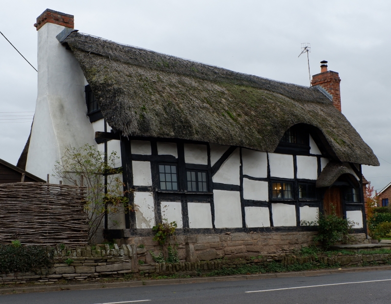
SP 01 57 INKBERROW CP HIGH STREET (east side)
10/95 Inteberga (formerly listed
as cottage approximately 90
30.7.59 yards NW on Home Farmhouse)
GV II
House. C17 with mid-C19 and C20 alterations. Timber-frame with rendered
infill and rendered plinth, thatched roof. Two framed bays aligned north/
south, large external stack to south gable, smaller external stack to north.
West front: one storey with attic lit by eyebrow dormer; four windows: 3-light
casement to left, single-light to centre, two 2-light casements to right;
entrance to right with ledged door. Framing: three square panels high with
straight angle braces; gable truss: three struts to collar.
Listing NGR: SP0141757165
External links are from the relevant listing authority and, where applicable, Wikidata. Wikidata IDs may be related buildings as well as this specific building. If you want to add or update a link, you will need to do so by editing the Wikidata entry.


Other nearby listed buildings
