Latitude: 52.0889 / 52°5'19"N
Longitude: -1.8996 / 1°53'58"W
OS Eastings: 406977
OS Northings: 243397
OS Grid: SP069433
Mapcode National: GBR 3LL.0KL
Mapcode Global: VHB0V.1R4J
Plus Code: 9C4W34Q2+H5
Entry Name: The Manor House
Listing Date: 30 July 1952
Grade: II*
Source: Historic England
Source ID: 1157643
English Heritage Legacy ID: 148613
ID on this website: 101157643
Location: Badsey, Wychavon, Worcestershire, WR11
County: Worcestershire
District: Wychavon
Civil Parish: Badsey
Built-Up Area: Badsey
Traditional County: Worcestershire
Lieutenancy Area (Ceremonial County): Worcestershire
Church of England Parish: Badsey with Aldington
Church of England Diocese: Worcester
Tagged with: House
BADSEY CP HIGH STREET (west side) SP 0643 - SP 0743
14/11 The Manor House (Nos 4 & 6)
30.7.52
GV II*
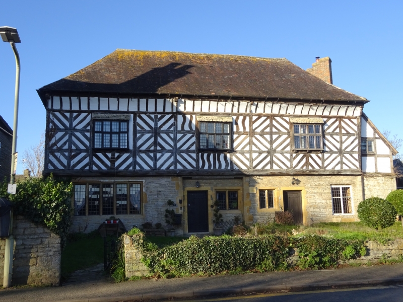
House. Late C16, restored mid-C20. Timber-frame with rendered infill on rubble ground floor with quoins and hipped tile roof. U-plan, front range formerly hall and carriage entry through it; south wing of six bays, north wing of two bays. Stack on side wall of north wing has three diamond brick shafts, other stack to junction of south wing and front range. Two storeys, coved cornice, three windows: oriels with lean-to stone tile roofs. Ground floor with four windows, that to left of five lights with stone mullions. Recessed portion to centre indicates carriage entry, now with C20 entrance to No 6. Entrance to No 4 to right. Framing: three square panels high with projecting moulded bressummer to first floor, with elaborate herring- bone bracing in panels. Interior: moulded stone fireplaces to main stacks. On the site of The Seyne House, a property of Evesham Abbey. Restored in 1940s by a group of local individuals, when the building had become very dilapidated. (BoE, p 74; Bond, C J: "The Estates of Evesham Abbey: a preliminary survey of their medieval topography", Vale of Evesham Historical Society Research Papers, Vol 4, 1973, p 9).
Listing NGR: SP0697743397
External links are from the relevant listing authority and, where applicable, Wikidata. Wikidata IDs may be related buildings as well as this specific building. If you want to add or update a link, you will need to do so by editing the Wikidata entry.


Other nearby listed buildings