Approximate Location Map
Large Map »
Latitude: 51.0242 / 51°1'27"N
Longitude: 0.9955 / 0°59'43"E
OS Eastings: 610164
OS Northings: 129252
OS Grid: TR101292
Mapcode National: GBR SZR.LJ3
Mapcode Global: FRA D6ZD.TXK
Plus Code: 9F322XFW+M5
Entry Name: Martello Tower No 24
Listing Date: 23 April 1985
Grade: II
Source: Historic England
Source ID: 1061124
English Heritage Legacy ID: 175512
ID on this website: 101061124
Location: Dymchurch, Folkestone and Hythe, Kent, TN29
County: Kent
District: Folkestone and Hythe
Civil Parish: Dymchurch
Built-Up Area: Dymchurch
Traditional County: Kent
Lieutenancy Area (Ceremonial County): Kent
TR 101 292 DYMCHURCH HIGH STREET
(A259)
(east side)
4/54 Martello Tower No.24
II
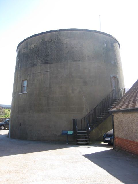
Martello Tower. 1806. Brick, covered in channelled cement render. Circular,
slightly tapering tower about 30 feet high. Walls said to be 5½-6 feet
thick. Shallow domed roof surrounded by projecting cement-rendered coping.
2 small horned recessed glazing bar sashes, one to north and one to south
with cills about 12 feet up. 2 small ventilation grilles towards base.
Vertical door with proud architrave and segmental head, with cill about 10
feet up, on west side. T-shaped recess below cill with surround continued
from door architrave. Flagpole and gun mounted on done. No.24 on plaque
over doorway. Now reached by external C20 metal staircase. Interior:
not inspected, but said to contain central brick pillar with vaulted arches,
magazine on ground floor and 2 rooms as quarters for garrison on first floor.
One of a series built in 1806 as gunposts against a possible Napoleonic
invasion. Stands immediately behind sea wall. Scheduled Ancient Monument.
See also High Street (east side) Martello Tower No.25 and Hythe Road (east
side) Martello Tower No.23. __ _____
Listing NGR: TR1016429252
External links are from the relevant listing authority and, where applicable, Wikidata. Wikidata IDs may be related buildings as well as this specific building. If you want to add or update a link, you will need to do so by editing the Wikidata entry.


Other nearby listed buildings
