Approximate Location Map
Large Map »
Latitude: 51.4582 / 51°27'29"N
Longitude: -0.3051 / 0°18'18"W
OS Eastings: 517853
OS Northings: 174611
OS Grid: TQ178746
Mapcode National: GBR 75.ZQF
Mapcode Global: VHGR2.NLLZ
Plus Code: 9C3XFM5V+7X
Entry Name: Lissoy
Listing Date: 10 January 1950
Grade: II*
Source: Historic England
Source ID: 1065353
English Heritage Legacy ID: 205581
ID on this website: 101065353
Location: Richmond upon Thames, London, TW10
County: London
District: Richmond upon Thames
Electoral Ward/Division: South Richmond
Parish: Non Civil Parish
Built-Up Area: Richmond upon Thames
Traditional County: Surrey
Lieutenancy Area (Ceremonial County): Greater London
Church of England Parish: Richmond
Church of England Diocese: Southwark
Tagged with: Building
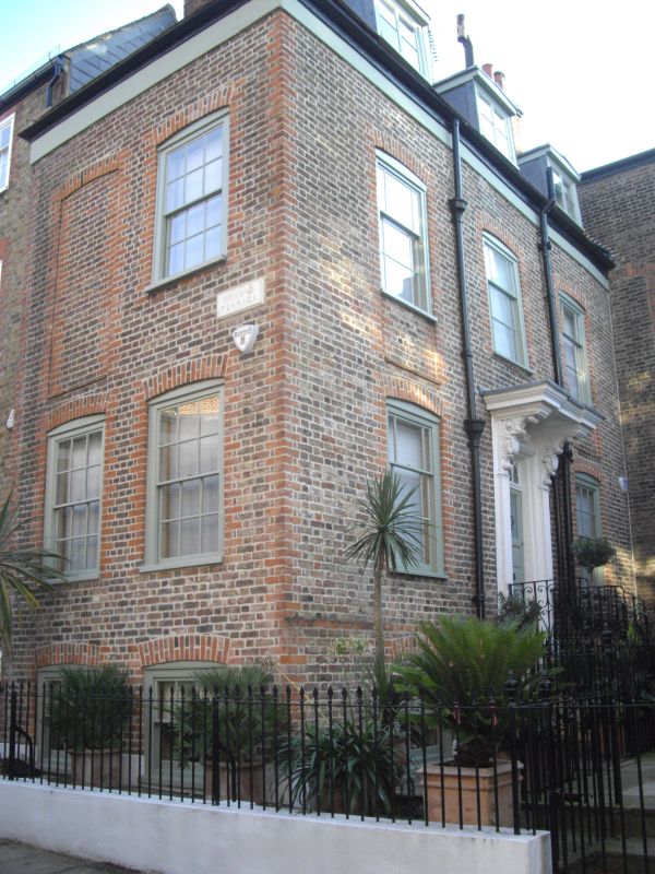
1.
5028 ORMOND ROAD
(south side)
"Lissoy"
10.1.50
II GV
2.
Faces towards Mill Street. Three-bay front with central doorway. Two windows to
Ormond Road. Doorway has fine doorcase with carved, bracketed hood and Gothick
fanlight.
Listing NGR: TQ1785474609
External links are from the relevant listing authority and, where applicable, Wikidata. Wikidata IDs may be related buildings as well as this specific building. If you want to add or update a link, you will need to do so by editing the Wikidata entry.


Other nearby listed buildings
