Approximate Location Map
Large Map »
Latitude: 52.7173 / 52°43'2"N
Longitude: 0.5058 / 0°30'20"E
OS Eastings: 569348
OS Northings: 316240
OS Grid: TF693162
Mapcode National: GBR P5L.NP3
Mapcode Global: WHKQD.RY1Q
Plus Code: 9F42PG84+W8
Entry Name: Hall Farmhouse Formerly Known As Church Farmhouse, C250M East of Church of All Saints
Listing Date: 20 June 1988
Grade: II
Source: Historic England
Source ID: 1077670
English Heritage Legacy ID: 221945
ID on this website: 101077670
Location: East Winch, King's Lynn and West Norfolk, Norfolk, PE32
County: Norfolk
District: King's Lynn and West Norfolk
Civil Parish: East Winch
Built-Up Area: East Winch
Traditional County: Norfolk
Lieutenancy Area (Ceremonial County): Norfolk
Tagged with: Farmhouse
EAST WINCH LYNN ROAD
TF 71 NW
(south side)
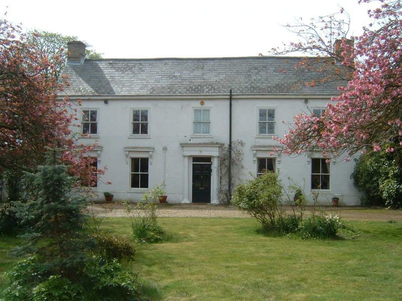
5/13 Hall Farmhouse
formerly known as Church
Farmhouse, c250m east
of Church of All Saints
II
Farmhouse, late C17 core with later additions. Rendered, slate roof, gault
brick end internal stacks. 5 bays, 2 storeys. Single range with cross wing
to rear of early C18. Secondary range of C19 within rear angle. Principal
facade to north, symmetrical, roll moulding to plinth; central doorway with
flanking attached Tuscan columns of wood, entablature, 6 panelled door part
glazed, rectangular light above. 4 recessed sashes to ground floor with
entablatures supported by consoles of acanthus leaves incorporating mythical
female face. 5 flush sashes to first floor. Right gable of galleted carstone
rubble with some courses of dressed limestone, red brick dressings, platband,
some brick courses to gable, small square opening to first floor left. Rear
wing to right with slate roof, varied materials including carstone, limestone,
rendering and C17 brick. Varied fenestration C19 3 bay range in angle of
main range and west wing, hipped roof to west, ground floor with central
doorway, recessed sash with glazing bars of 4 x 4 panes to right, lean-to
to left; 3 recessed sashes to first floor. Interior: stair with splat shaped
balusters.
Listing NGR: TF6934816240
External links are from the relevant listing authority and, where applicable, Wikidata. Wikidata IDs may be related buildings as well as this specific building. If you want to add or update a link, you will need to do so by editing the Wikidata entry.


Other nearby listed buildings
