Approximate Location Map
Large Map »
Latitude: 55.2859 / 55°17'9"N
Longitude: -1.8171 / 1°49'1"W
OS Eastings: 411714
OS Northings: 599105
OS Grid: NZ117991
Mapcode National: GBR H7R9.DY
Mapcode Global: WHC23.1DZK
Plus Code: 9C7W75PM+95
Entry Name: Farmbuilding Range on West of Yard at Brinkburn Lodge
Listing Date: 15 September 1988
Grade: II
Source: Historic England
Source ID: 1041900
English Heritage Legacy ID: 236736
ID on this website: 101041900
Location: Northumberland, NE65
County: Northumberland
Civil Parish: Brinkburn
Traditional County: Northumberland
Lieutenancy Area (Ceremonial County): Northumberland
Church of England Parish: Longframlington with Brinkburn
Church of England Diocese: Newcastle
Tagged with: Agricultural structure
BRINKBURN B 6334
NZ 19 NW
(South side)
10/68 Farmbuilding range
on west of yard
at Brinkburn Lodge
GV II
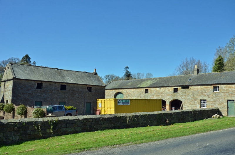
Cartshed, shelter sheds, granary and bothy. Early C19. Squared stone with
tooled-and-margined quoins and dressings; blue slate roof. 1 + 2 storeys,
6 irregular bays. Boarded double doors under tall segmental-arched cart
entrance at left end; arcade of 3 similar but lower arches in centre, with 2
windows above and boarded opening with pigeon holes above right. Bothy at
right end has boarded door with 5-pane overlight, 16-pane sash to left and
6-pane casement on 1st floor. Coped gables; banded ridge stack, rendered, to
bothy. Right return shows O.S.B.M. Rear elevation shows boarded door to
cart shed; 2 windows to granary; 8-pane sash with external iron bars and 1st
floor 6-pane casement to bothy.
Listing NGR: NZ1171499105
External links are from the relevant listing authority and, where applicable, Wikidata. Wikidata IDs may be related buildings as well as this specific building. If you want to add or update a link, you will need to do so by editing the Wikidata entry.


Other nearby listed buildings
