Latitude: 55.1669 / 55°10'0"N
Longitude: -1.6869 / 1°41'12"W
OS Eastings: 420043
OS Northings: 585885
OS Grid: NZ200858
Mapcode National: GBR J8NP.LM
Mapcode Global: WHC2R.1DZB
Plus Code: 9C7W5887+Q6
Entry Name: The Chantry
Listing Date: 11 August 1950
Last Amended: 22 August 1986
Grade: I
Source: Historic England
Source ID: 1042759
English Heritage Legacy ID: 238707
ID on this website: 101042759
Location: Morpeth, Northumberland, NE61
County: Northumberland
Civil Parish: Morpeth
Built-Up Area: Morpeth
Traditional County: Northumberland
Lieutenancy Area (Ceremonial County): Northumberland
Church of England Parish: Morpeth
Church of England Diocese: Newcastle
Tagged with: Church building
MORPETH CHANTRY PLACE NZ 2085
25/222 The Chantry (formerly listed as 11.8.50 Chantry Wells) )
GV I
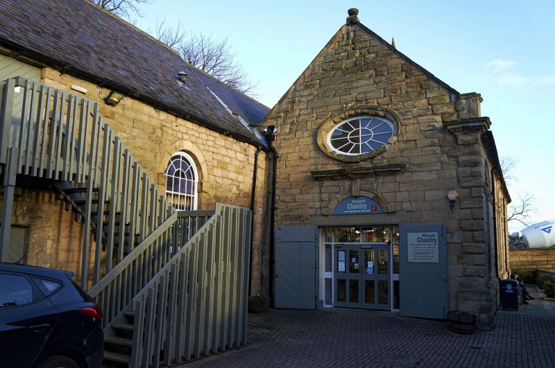
Former chantry chapel of All Saints, later a grammar school and various other uses. Now used as tourist information centre. c.1300 and 1738. Random rubble to older parts. Later parts ashlar. Welsh slate roofs. Double-span roof.
North side has largely medieval masonry wth irregular openings. Blocked double- chamfered C13 transept arch; also a blocked pointed-arched doorway and a blocked lancet. To right a C20 shop front. Right return, i.e. west end of former church, has pointed-arched portal in multi-moulded surround. 2 double-chamfered pointed-arched windows above with C19 wood tracery. Bellcote over. Left return is of 1738 with 2 round-headed windows with intersecting glazing bars in raised surrounds with impost blocks; oval oeil de boeuf window over, all set in earlier pointed arch.
South side is of 1738. Rusticated quoins. 5 bays.
Tall round-headed windows with intersecting glazing bars; impost blocks linked by string; moulded arches.
Gabled roofs with flat coping and urn finials.
Interior: 3-bay C18 arcade with round piers and arches with architraves. 2 blocked pointed-arched doorways. Medieval roof timbers in older part.
Listing NGR: NZ2004285889
External links are from the relevant listing authority and, where applicable, Wikidata. Wikidata IDs may be related buildings as well as this specific building. If you want to add or update a link, you will need to do so by editing the Wikidata entry.


Other nearby listed buildings