Approximate Location Map
Large Map »
Latitude: 53.3189 / 53°19'8"N
Longitude: -1.1724 / 1°10'20"W
OS Eastings: 455225
OS Northings: 380538
OS Grid: SK552805
Mapcode National: GBR NZ71.ZZ
Mapcode Global: WHDF0.YVV1
Plus Code: 9C5W8R9H+H2
Entry Name: Haha at Shireoaks Hall
Listing Date: 1 April 1985
Grade: II
Source: Historic England
Source ID: 1370409
English Heritage Legacy ID: 241216
ID on this website: 101370409
Location: Shireoaks, Bassetlaw, Nottinghamshire, S81
County: Nottinghamshire
District: Bassetlaw
Civil Parish: Shireoaks
Traditional County: Nottinghamshire
Lieutenancy Area (Ceremonial County): Nottinghamshire
Church of England Parish: Worksop Christ Church and Shireoaks
Church of England Diocese: Southwell and Nottingham
Tagged with: Ha-ha
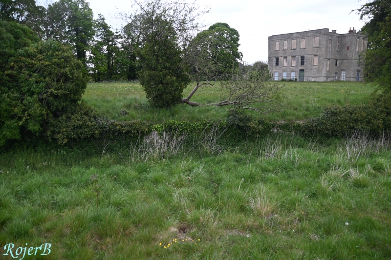
SK 58 SE SHIREOAKS THORPE LANE
(South side)
1/8 HaHa at
Shireoaks Hall
G.V. II
HaHa. Early C18. 100 M to south west of house. Fine
irregularly coursed squared rubble with ashlar coping. Approx.
150 M long. Included for group value only.
Listing NGR: SK5522580538
External links are from the relevant listing authority and, where applicable, Wikidata. Wikidata IDs may be related buildings as well as this specific building. If you want to add or update a link, you will need to do so by editing the Wikidata entry.


Other nearby listed buildings
