Approximate Location Map
Large Map »
Latitude: 53.1733 / 53°10'24"N
Longitude: -0.7662 / 0°45'58"W
OS Eastings: 482566
OS Northings: 364736
OS Grid: SK825647
Mapcode National: GBR CKJ.52J
Mapcode Global: WHFH4.6HDL
Plus Code: 9C5X56FM+8G
Entry Name: Parish Church and Boundary Wall
Listing Date: 17 October 1984
Grade: II
Source: Historic England
Source ID: 1046061
English Heritage Legacy ID: 242528
ID on this website: 101046061
Location: Holy Trinity Church, Besthorpe, Newark and Sherwood, Nottinghamshire, NG23
County: Nottinghamshire
District: Newark and Sherwood
Civil Parish: Besthorpe
Traditional County: Nottinghamshire
Lieutenancy Area (Ceremonial County): Nottinghamshire
Church of England Parish: South Scarle with Besthorpe Girton and Spalford
Church of England Diocese: Southwell and Nottingham
Tagged with: Church building
SK 86 SW BESTHORPE THE GREEN
(west side)
5/3 Parish Church and
Boundary wall
G.V. II
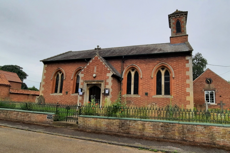
Parish Church, 1844: brick with welsh slate and stone slab roofs, stone
dressings, coped gables with kneelers. Nave with apse, gabled south porch,
bell turret. South front has central porch with coped gable and cross, four
centred arched doorway with label mould and close boarded door flanked by 2
double lancets with Y tracery. Apse has 3 single lancets and pitched roof.
Bell turret has single lancet on each side, modillioned eaves, pyramidal slab
roof with cross. Interior rendered except window reveals. Brick chancel
arch with moulded ashlar soffit, responds and quoins. At west end, 2
wood-cased iron columns supporting bell turret. Nave roof has tie beam
with 3 decorative pendants, supported by curved brackets on carved wooden
corbels. Queen posts with arch braces to purlins and curved brackets forming
mouchettes in spandrels. Apse roof semi circular with common rafters. Plain
C19 deal pews, communion rail 1898. Boundary wall, brick, with cast iron
coping carrying ornate cast iron railing and gate.
Listing NGR: SK8256664736
External links are from the relevant listing authority and, where applicable, Wikidata. Wikidata IDs may be related buildings as well as this specific building. If you want to add or update a link, you will need to do so by editing the Wikidata entry.


Other nearby listed buildings
