Approximate Location Map
Large Map »
Latitude: 51.528 / 51°31'40"N
Longitude: -0.9726 / 0°58'21"W
OS Eastings: 471368
OS Northings: 181513
OS Grid: SU713815
Mapcode National: GBR C4W.0YB
Mapcode Global: VHDWF.3V5H
Plus Code: 9C3XG2HG+6X
Entry Name: Church of All Saints
Listing Date: 13 February 1985
Grade: II*
Source: Historic England
Source ID: 1369298
English Heritage Legacy ID: 247166
ID on this website: 101369298
Location: All Saints' Church, Rotherfield Peppard, South Oxfordshire, RG9
County: Oxfordshire
District: South Oxfordshire
Civil Parish: Rotherfield Peppard
Built-Up Area: Rotherfield Peppard
Traditional County: Oxfordshire
Lieutenancy Area (Ceremonial County): Oxfordshire
Church of England Parish: Rotherfield Peppard
Church of England Diocese: Oxford
Tagged with: Church building
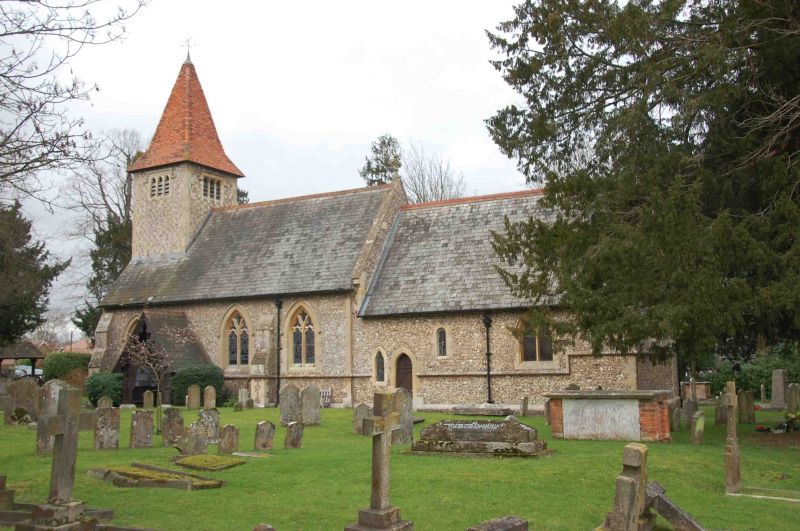
ROTHERFIELD PEPPARD
SU78SW
6/144 Church of All Saints
- II*
Church. Romanesque, restored 1874 by William Scott Champion, who added
north aisle. C20 vestry and parish room. Flint with stone dressing; tower
flint and stone in random chequer; slate roof to church; plain tile roof to
tower. 4 bay nave with 3 bay north aisle, 2 bay chancel and west tower.
Timber-frame porch of 1908 to left of centre with decorative barge-boards.
Studded door. Three 2-light windows of reticulated tracery to nave. Plank
studded door to chancel with single trefoil-topped lancet to left. C12 window
to centre. 2-light plate-tracery window to right. Tower of 1908 rises from
ridge to left; 3-light perpendicular-style window under label mould with
dropped ends, to each side; pyramidal roof. 3-light window of reticulated
tracery to right return. Interior: Romanesque font; round; with cable
moulding. East window flanked by Romanesque arches. C13 pointed chancel arch
on Romanesque shafts with carved capitals. Trefoil arched trusses to nave,
wood barrel vault to chancel.
(Buildings of England : Oxfordshire, p.737; All Saints Church Rotherfield
Peppard, A Short History, 1982).
Listing NGR: SU7136881513
External links are from the relevant listing authority and, where applicable, Wikidata. Wikidata IDs may be related buildings as well as this specific building. If you want to add or update a link, you will need to do so by editing the Wikidata entry.


Other nearby listed buildings
