Approximate Location Map
Large Map »
Latitude: 51.6822 / 51°40'55"N
Longitude: -1.1252 / 1°7'30"W
OS Eastings: 460576
OS Northings: 198524
OS Grid: SU605985
Mapcode National: GBR 902.JBF
Mapcode Global: VHCY3.GZ09
Plus Code: 9C3WMVJF+VW
Entry Name: The Limes and Attached Outbuildings
Listing Date: 19 August 1986
Grade: II
Source: Historic England
Source ID: 1047992
English Heritage Legacy ID: 248396
ID on this website: 101047992
Location: Stadhampton, South Oxfordshire, OX44
County: Oxfordshire
District: South Oxfordshire
Civil Parish: Stadhampton
Traditional County: Oxfordshire
Lieutenancy Area (Ceremonial County): Oxfordshire
Church of England Parish: Stadhampton with Chiselhampton
Church of England Diocese: Oxford
Tagged with: Building
SU6098
14/157
STADHAMPTON
THE GREEN
(East side)
The Lines and attached outbuildings
GV
II
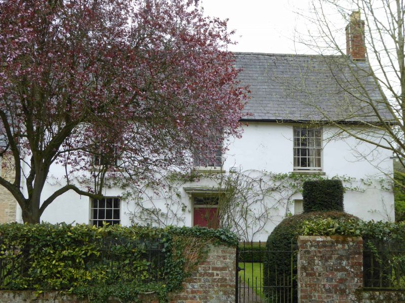
Farmhouse, now house. Early C18 with C17 gable wall and c.1800 front. Limestone
rubble with brick dressings, some rendering, and timber framing with brick
infill; Welsh-slate roof with brick gable stack. Central-stair plan. 2 storeys
plus attics. Symmetrical 3-window rendered front, rising from a rubble and brick
plinth, has central 4-panel door, with decorative rectangular overlight and flat
canopy on shaped brackets, and has 16-pane sashes. Roof has stack to right.
Right gable wall and rear are rubble with brick dressings and storey band.
Moulded-brick plinth weathering continues from front. Rear was formerly
symmetricial with segmental arches at ground floor. Left gable, rising above
roof of Green Cottage (q.v.), is timber framed. Interior: dog-leg stair, rising
to attics, with closed string, heavy turned balusters and winders; early C18
bolection panelling, stone fireplace, curved alcoves and cornices. Attached
rubble and tile outbuilding range runs behind Green Cottage which may have been
a service wing.
Listing NGR: SU6057698524
External links are from the relevant listing authority and, where applicable, Wikidata. Wikidata IDs may be related buildings as well as this specific building. If you want to add or update a link, you will need to do so by editing the Wikidata entry.


Other nearby listed buildings
