Latitude: 51.5844 / 51°35'3"N
Longitude: -1.6704 / 1°40'13"W
OS Eastings: 422934
OS Northings: 187334
OS Grid: SU229873
Mapcode National: GBR 5WJ.QHJ
Mapcode Global: VHC0Y.0F9R
Plus Code: 9C3WH8MH+QR
Entry Name: Bourton Grange
Listing Date: 11 December 1985
Grade: II
Source: Historic England
Source ID: 1048738
English Heritage Legacy ID: 250669
ID on this website: 101048738
Location: Lower Bourton, Vale of White Horse, Oxfordshire, SN6
County: Oxfordshire
District: Vale of White Horse
Civil Parish: Bourton
Traditional County: Berkshire
Lieutenancy Area (Ceremonial County): Oxfordshire
Church of England Parish: Shrivenham with Watchfield and Bourton
Church of England Diocese: Oxford
Tagged with: Building
BOURTON SU28NW 4/40 Bourton Grange
GV II
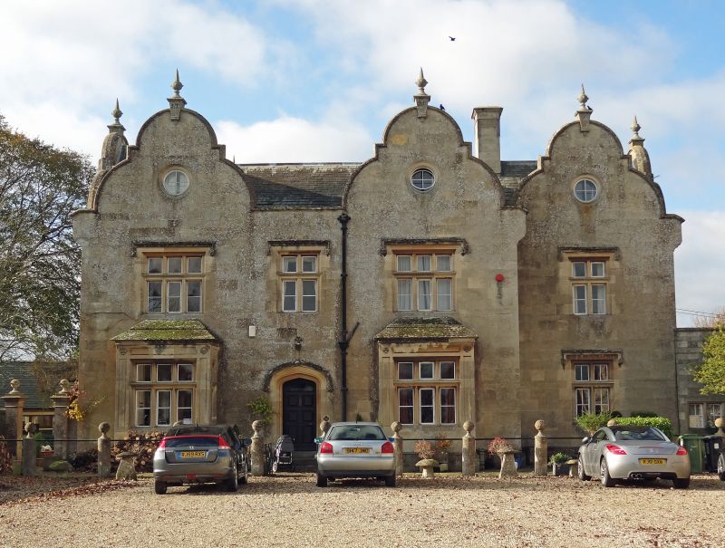
House, now office. Datestone on finial: JT (for John Tucker) 1847. Limestone ashlar. Welsh slate roof. Double-depth plan (4x2) with central staircase. 2-storey and attic, 4-window range. 3:1 facade with bay recessed, built flush with service range. Steps to 6-panelled door, under 4-centered arch with hood mould and ballflower terminals over; door flanked by 2 rectangular bays, with blind panel strips and lunettes to surround. 4-light moulded mullioned and transomed windows; ballflower terminals to hood moulds; original rainwater goods. Facade surmounted by 3 Dutch gables with moulded kneelers and round window; ridge stacks. Interior: Original panelled doors and straight-flight open-string stair with moulded balusters; service range to right of facade: limestone ashlar, 3-window range, with flat roof. In front of house is late C20 iron rail connected by stone circular piers with ball finials. John Turner, the builder of Bourton Grange, also built the 6 almshouses near Pinewood and contributed towards the rebuilding of the school. The Tucker family were responsible for the building of much of Bourton in the 1840s & 1850s, including Pinewood, the Church of St. James and the Baptist chapel. (Kelly's Directory, 1897).
Listing NGR: SU2293487334
External links are from the relevant listing authority and, where applicable, Wikidata. Wikidata IDs may be related buildings as well as this specific building. If you want to add or update a link, you will need to do so by editing the Wikidata entry.


Other nearby listed buildings