Approximate Location Map
Large Map »
Latitude: 51.7428 / 51°44'33"N
Longitude: -1.6315 / 1°37'53"W
OS Eastings: 425538
OS Northings: 204961
OS Grid: SP255049
Mapcode National: GBR 5TN.NBH
Mapcode Global: VHC05.NGVB
Plus Code: 9C3WP9V9+49
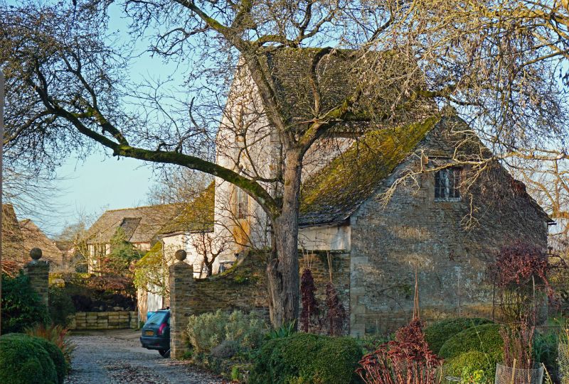
Entry Name: Stable Range 25 Metres to North of Kencot House, with Attached Wall and Gatepier on East Side of Stable Yard
Listing Date: 4 May 1989
Grade: II
Source: Historic England
Source ID: 1053505
English Heritage Legacy ID: 253536
ID on this website: 101053505
Location: Kencot, West Oxfordshire, GL7
County: Oxfordshire
District: West Oxfordshire
Civil Parish: Kencot
Built-Up Area: Broadwell
Traditional County: Oxfordshire
Lieutenancy Area (Ceremonial County): Oxfordshire
Church of England Parish: Kencot
Church of England Diocese: Oxford
Tagged with: Stable
SP2404-2504 KENCOT
8/224 Stable range 25m to N of
Kencot House, with attached
wall and gatepier on E side of
stable yard
GV II
Stable range. Early-mid C19 with some later alterations. Coursed rubble
limestone with dressed quoins and stone slate roofs. Tall centre bay with
vehicle entry, flanked by lower stable wings, in Gothick style. Centre bay has
coped gable to front and is very slightly advanced. It has a vehicle entry with
dressed stone jambs and wooden lintel, a 2-light leaded window with wooden
Y-tracery, 4-centred arch and hoodmould, and a square clock panel with blind
tracery and Tudor hoodmould. Above clock panel is an arched bellcote. To left is
a 2-bay lofted stable. This has 2-light leaded windows with 4-centred wooden
tracery and blind tympana in semi-circular arched surrounds of dressed stone.
Central board door with wooden lintel and small boarded loft door above.
Contains 3 stable boxes. Attached to left end is a lower bay with half-hipped
roof and C20 garage doors. To right of centre is an altered wing, formerly open
to front, with later stone and rendered infill. This has 2 board doors, small
projection to right, and single loft light with Tudor hood in right gable.
Attached to front right is a short length of stable-yard wall, ramped down to
gatepier, with blocked archway. Wall and pier are probably late C19-C20, of
rubble stone, the pier with pyramid cap and ball finial. Included for group
value.
Listing NGR: SP2553804961
External links are from the relevant listing authority and, where applicable, Wikidata. Wikidata IDs may be related buildings as well as this specific building. If you want to add or update a link, you will need to do so by editing the Wikidata entry.


Other nearby listed buildings
