Approximate Location Map
Large Map »
Latitude: 52.5362 / 52°32'10"N
Longitude: -2.4196 / 2°25'10"W
OS Eastings: 371638
OS Northings: 293226
OS Grid: SO716932
Mapcode National: GBR BZ.F71S
Mapcode Global: VH90Z.0JQ4
Plus Code: 9C4VGHPJ+F5
Entry Name: 65, High Street
Listing Date: 1 February 1974
Grade: II
Source: Historic England
Source ID: 1367490
English Heritage Legacy ID: 254453
ID on this website: 101367490
Location: Bridgnorth, Shropshire, WV16
County: Shropshire
Civil Parish: Bridgnorth
Built-Up Area: Bridgnorth
Traditional County: Shropshire
Lieutenancy Area (Ceremonial County): Shropshire
Church of England Parish: Bridgnorth
Church of England Diocese: Hereford
Tagged with: Building
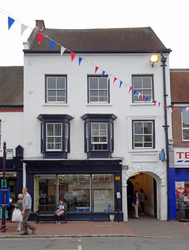
1.
1954 BRIDGNORTH
HIGH STREET
(East Side)
No 65
SO 79 SW 2/116
II GV
2.
Late C18. Engraved stucco; 3 storeys; 2 three-light canted oriel windows
(single glazing bars) and one sash window in moulded and voluted architrave;
parapeted gable on left-hand side; plain eaves; old tiles. C19 shop fronts.
No 65 & Nos 71 to 73 (consec) form a group
Listing NGR: SO7163893226
External links are from the relevant listing authority and, where applicable, Wikidata. Wikidata IDs may be related buildings as well as this specific building. If you want to add or update a link, you will need to do so by editing the Wikidata entry.


Other nearby listed buildings
