Approximate Location Map
Large Map »
Latitude: 52.537 / 52°32'13"N
Longitude: -2.4196 / 2°25'10"W
OS Eastings: 371638
OS Northings: 293324
OS Grid: SO716933
Mapcode National: GBR BZ.F71G
Mapcode Global: VH90Z.0HQG
Plus Code: 9C4VGHPJ+R5
Entry Name: 26 and 27, St Leonards Close
Listing Date: 18 July 1949
Grade: II
Source: Historic England
Source ID: 1367485
English Heritage Legacy ID: 254526
ID on this website: 101367485
Location: High Town, Shropshire, WV16
County: Shropshire
Civil Parish: Bridgnorth
Built-Up Area: Bridgnorth
Traditional County: Shropshire
Lieutenancy Area (Ceremonial County): Shropshire
Church of England Parish: Bridgnorth
Church of England Diocese: Hereford
Tagged with: Building
1.
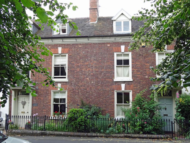
1954 BRIDGNORTH
ST LEONARD'S CLOSE
Nos 26 and 27
SO 79 SW 2/193 18.7.49.
II GV
2.
Early to mid C18. Red brick; 2 storeys; 4 modern sash windows with orginal
keyblocks; stone pilaster at sides; 2 identical moulded wood doorcases
with later wood canopies; moulded stone eaves; 4 restored gabled dormers;
old tiles.
Nos 26 to 30 (consec) form a group
Listing NGR: SO7163893324
External links are from the relevant listing authority and, where applicable, Wikidata. Wikidata IDs may be related buildings as well as this specific building. If you want to add or update a link, you will need to do so by editing the Wikidata entry.


Other nearby listed buildings
