Approximate Location Map
Large Map »
Latitude: 52.5441 / 52°32'38"N
Longitude: -2.2762 / 2°16'34"W
OS Eastings: 381366
OS Northings: 294064
OS Grid: SO813940
Mapcode National: GBR 08H.FCH
Mapcode Global: VH911.HBJ1
Plus Code: 9C4VGPVF+JG
Entry Name: Newin House
Listing Date: 9 March 1970
Grade: II
Source: Historic England
Source ID: 1053879
English Heritage Legacy ID: 254641
ID on this website: 101053879
Location: Upper Aston, Shropshire, WV5
County: Shropshire
Civil Parish: Claverley
Traditional County: Shropshire
Lieutenancy Area (Ceremonial County): Shropshire
Church of England Parish: Claverley
Church of England Diocese: Hereford
Tagged with: House
SO 89 SW 24/53;
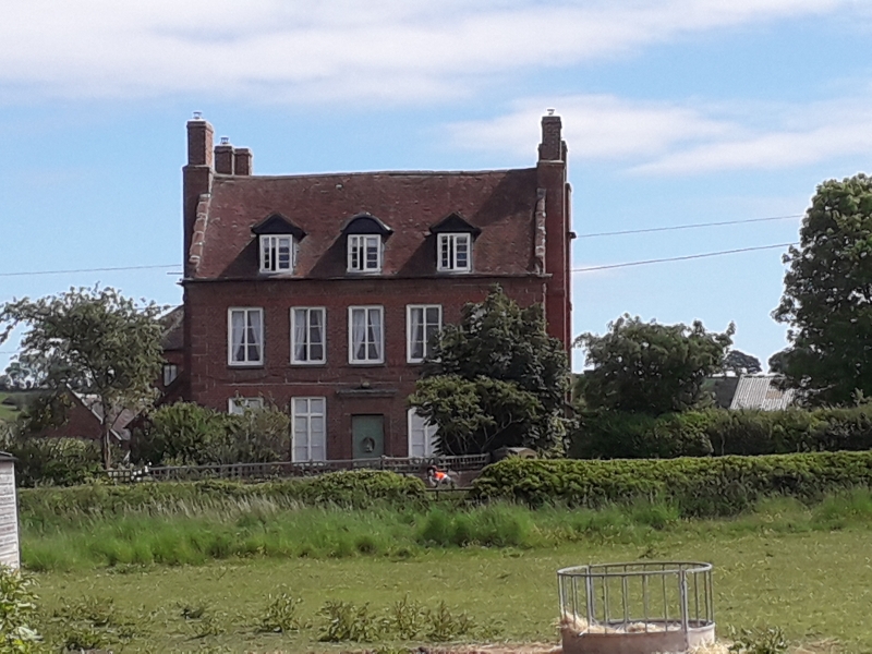
CLAVERLEY,
Newin House
9.3.70.
II
Circa 1700. Formerly an inn. Brick with stone dressings, rusticated
quoins, coped gables and tiled roof; two storeys and attic; sashes and casements;
5-window front, the attic windows gabled; square framed moulded stone
doorway; metal verandah on one side; moulded eaves cornice; brick stacks.
Listing NGR: SO8136694064
External links are from the relevant listing authority and, where applicable, Wikidata. Wikidata IDs may be related buildings as well as this specific building. If you want to add or update a link, you will need to do so by editing the Wikidata entry.


Other nearby listed buildings
