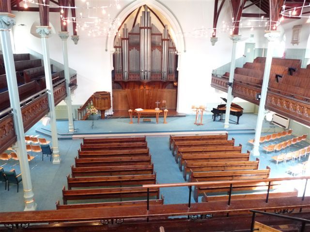
Latitude: 51.0119 / 51°0'42"N
Longitude: -3.1048 / 3°6'17"W
OS Eastings: 322592
OS Northings: 124196
OS Grid: ST225241
Mapcode National: GBR M1.JF8K
Mapcode Global: FRA 46DF.L8R
Plus Code: 9C3R2V6W+Q3
Entry Name: Temple Methodist Church Temple Methodist Schools
Listing Date: 4 July 1975
Grade: II
Source: Historic England
Source ID: 1344791
English Heritage Legacy ID: 269945
ID on this website: 101344791
Location: Taunton, Somerset, TA1
County: Somerset
District: Somerset West and Taunton
Electoral Ward/Division: Taunton Manor and Wilton
Parish: Taunton
Built-Up Area: Taunton
Traditional County: Somerset
Lieutenancy Area (Ceremonial County): Somerset
Tagged with: Architectural structure
1. UPPER HIGH STREET 5365 (North Side) ) Temple Methodist Church Temple Methodist Schools ST 2224 SE 11/411 II GV 2. 1868 by J Wilson. The church has gable end to street. 2 storey white brick front with ashlar dressings. Diagonal buttresses with setoffs flank the centre section and polygonal turrets flank the outer sections. Cornice with some sculptured details and gable parapet with finials. Quatrefoil in gable. Stringcourse. Large traceried 3 light window over entrance. Otherwise simple 2 light traceried windows. Central pointed doorway with moulded surround. Other pointed doorways in turrets. 2 window extension to left in similar Decorated style. 3 window gable end of Wesleyan Temple Schools, rebuilt in 1868, adjoins on right.
Temple Methodist Church and Schools, and Nos 42 & 43 form a group.
Listing NGR: ST2259224196
External links are from the relevant listing authority and, where applicable, Wikidata. Wikidata IDs may be related buildings as well as this specific building. If you want to add or update a link, you will need to do so by editing the Wikidata entry.


Other nearby listed buildings