Approximate Location Map
Large Map »
Latitude: 52.0833 / 52°5'0"N
Longitude: 0.916 / 0°54'57"E
OS Eastings: 599897
OS Northings: 246789
OS Grid: TL998467
Mapcode National: GBR SKV.BDY
Mapcode Global: VHKF0.TWMS
Plus Code: 9F423WM8+8C
Entry Name: Church of All Saints
Listing Date: 10 July 1980
Grade: II
Source: Historic England
Source ID: 1351576
English Heritage Legacy ID: 277093
ID on this website: 101351576
Location: All Saints' Church, Semer, Babergh, Suffolk, IP7
County: Suffolk
District: Babergh
Civil Parish: Semer
Traditional County: Suffolk
Lieutenancy Area (Ceremonial County): Suffolk
Church of England Parish: Semer All Saints
Church of England Diocese: St.Edmundsbury and Ipswich
Tagged with: Church building
SEMER CHURCH LANE
1.
5377
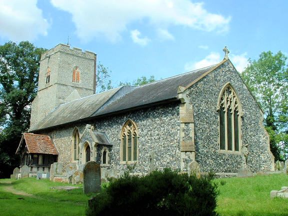
Church of All Saints
TL 94 NE 37/942 23.1.58
II
2.
A church of C14 and C15 origin, flint and stone. Castellated west tower,
Very much renovated in the C19. The interior has a plain C14 square
font and a wall painting of Moses and Aaron (C18).
Listing NGR: TL9989746789
External links are from the relevant listing authority and, where applicable, Wikidata. Wikidata IDs may be related buildings as well as this specific building. If you want to add or update a link, you will need to do so by editing the Wikidata entry.


Other nearby listed buildings
