Approximate Location Map
Large Map »
Latitude: 52.2836 / 52°17'0"N
Longitude: 1.139 / 1°8'20"E
OS Eastings: 614208
OS Northings: 269692
OS Grid: TM142696
Mapcode National: GBR TJZ.SXK
Mapcode Global: VHL9M.PVJR
Plus Code: 9F4374MQ+CJ
Entry Name: Church Farmhouse
Listing Date: 23 June 1988
Grade: II
Source: Historic England
Source ID: 1032356
English Heritage Legacy ID: 281379
ID on this website: 101032356
Location: Thorndon, Mid Suffolk, IP23
County: Suffolk
District: Mid Suffolk
Civil Parish: Thorndon
Built-Up Area: Thorndon
Traditional County: Suffolk
Lieutenancy Area (Ceremonial County): Suffolk
Church of England Parish: Thorndon with Rishangles All Saints
Church of England Diocese: St.Edmundsbury and Ipswich
Tagged with: Farmhouse
TM 16 NW
3/98
THORNDON
THE STREET (off)
Church Farmhouse
GV
II
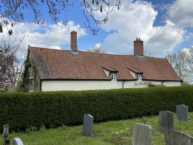
Farmhouse. Medieval origins, largely rebuilt c.1600 as a 3-cell house. Later
in-line service addition to left (west). Timber framed, the front plastered
and lined in imitation of ashlar. Roughcast render to gable ends, one dated
1909. Pantiled roof. 1½ storeys. 3 windows, C20 casements. Lobby entrance
with lean-to porch and glazed 4-panel door. 2 catslide dormers with older
casement windows. Internal stack with tall oblong shaft. Small square-
shafted stack at former gable end to left. Full-height studding exposed in
parlour cell, very little elsewhere. Many timbers are re-used. 2 diamond-
mullioned windows in parlour chamber. Service end has some heavy square
joists, probably medieval. Chamfered joists in hall, plain joists in parlour.
Hall fireplace contains some re-used stonework; opposite fireplace in parlour
has 3-centred brick arch. Straight stair at lower end of hall, a C19 or C20
insertion. Roof timbers concealed.
Listing NGR: TM1420869692
External links are from the relevant listing authority and, where applicable, Wikidata. Wikidata IDs may be related buildings as well as this specific building. If you want to add or update a link, you will need to do so by editing the Wikidata entry.


Other nearby listed buildings
