Approximate Location Map
Large Map »
Latitude: 50.9607 / 50°57'38"N
Longitude: 0.403 / 0°24'10"E
OS Eastings: 568850
OS Northings: 120668
OS Grid: TQ688206
Mapcode National: GBR NTF.LQK
Mapcode Global: FRA C6QK.YMF
Plus Code: 9F22XC63+75
Entry Name: The Hermit's Tower
Listing Date: 13 May 1987
Grade: II
Source: Historic England
Source ID: 1044087
English Heritage Legacy ID: 292423
ID on this website: 101044087
Location: Hollingrove, Rother, East Sussex, TN32
County: East Sussex
District: Rother
Civil Parish: Brightling
Traditional County: Sussex
Lieutenancy Area (Ceremonial County): East Sussex
Church of England Parish: Brightling St Thomas a Becket
Church of England Diocese: Chichester
Tagged with: Building
TQ 6820-6920 BRIGHTLING BRIGHTLING ROAD
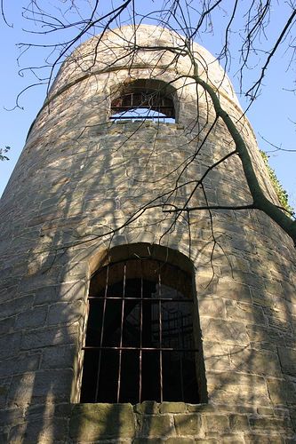
38/15 The Hermit's Tower, Brightling
Park
II
Ornamental tower built by the eccentric John Fuller to house a hermit. Early
C19. Lower circular tower of sandstone with castellated parapet.
Listing NGR: TQ6885020668
External links are from the relevant listing authority and, where applicable, Wikidata. Wikidata IDs may be related buildings as well as this specific building. If you want to add or update a link, you will need to do so by editing the Wikidata entry.


Other nearby listed buildings
