Approximate Location Map
Large Map »
Latitude: 51.1742 / 51°10'27"N
Longitude: -2.3008 / 2°18'2"W
OS Eastings: 379067
OS Northings: 141705
OS Grid: ST790417
Mapcode National: GBR 0T3.73Z
Mapcode Global: VH97M.2RJ7
Plus Code: 9C3V5MFX+MM
Entry Name: County Boundary Post on Road Bridge at Junction to Horningsham
Listing Date: 9 September 1987
Grade: II
Source: Historic England
Source ID: 1318444
English Heritage Legacy ID: 321203
ID on this website: 101318444
Location: Wiltshire, BA11
County: Wiltshire
Civil Parish: Maiden Bradley with Yarnfield
Traditional County: Wiltshire
Lieutenancy Area (Ceremonial County): Somerset
Church of England Parish: The Deverills and Horningsham
Church of England Diocese: Salisbury
Tagged with: Architectural structure Boundary marker
MAIDEN BRADLEY FROME ROAD
ST 74 SE
(east side)
1/97 County Boundary post on
road bridge at junction to
Horningsham
II
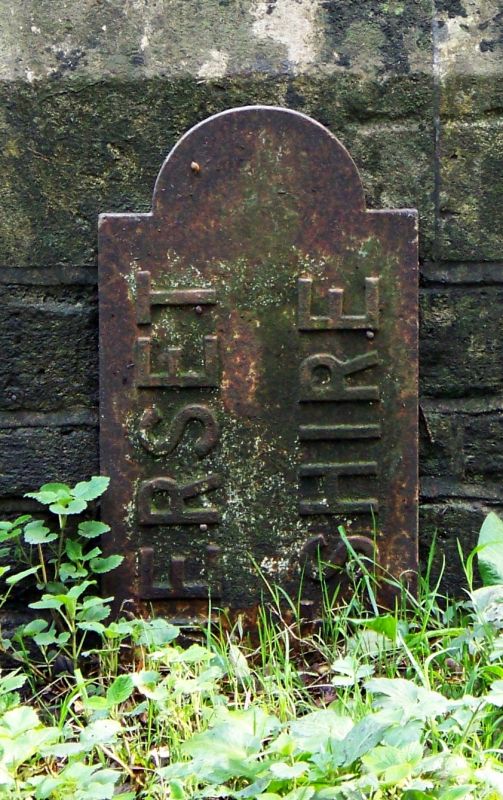
County boundary post. C19. Cast iron plate with semi-circular
top and WILTSHIRE / SOMERSET in raised lettering, vertically on
front.
Listing NGR: ST7906741705
External links are from the relevant listing authority and, where applicable, Wikidata. Wikidata IDs may be related buildings as well as this specific building. If you want to add or update a link, you will need to do so by editing the Wikidata entry.


Other nearby listed buildings
