Approximate Location Map
Large Map »
Latitude: 54.0809 / 54°4'51"N
Longitude: -2.2737 / 2°16'25"W
OS Eastings: 382187
OS Northings: 465029
OS Grid: SD821650
Mapcode National: GBR DPK7.JW
Mapcode Global: WHB6K.1PJD
Plus Code: 9C6V3PJG+8G
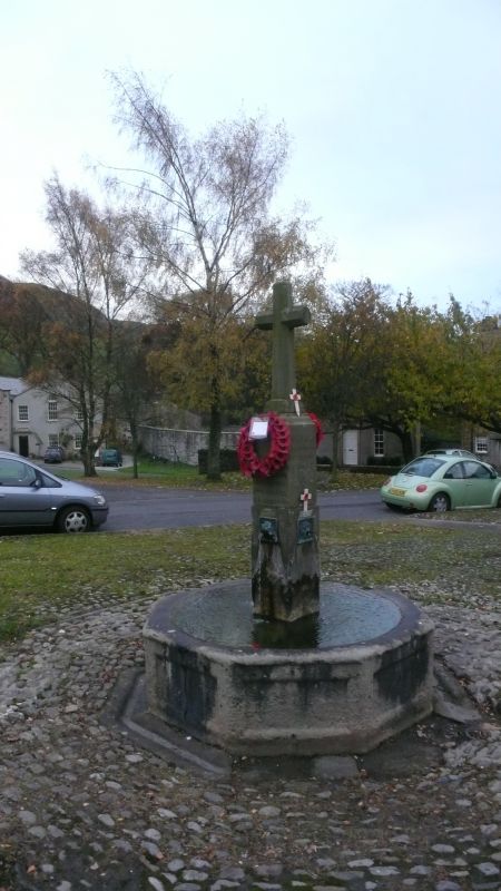
Entry Name: Fountain Basin
Listing Date: 13 September 1988
Grade: II
Source: Historic England
Source ID: 1132393
English Heritage Legacy ID: 324240
ID on this website: 101132393
Location: Langcliffe, North Yorkshire, BD24
County: North Yorkshire
District: Craven
Civil Parish: Langcliffe
Traditional County: Yorkshire
Lieutenancy Area (Ceremonial County): North Yorkshire
Church of England Parish: Langcliffe St John the Evangelist
Church of England Diocese: Leeds
Tagged with: Fountain
LANGCLIFFE
SD 86 NW
2/2 Fountain basin
GV II
Fountain basin. C18 or early C19. Stone. Octagonal basin, each side carved with
recessed panel. Fountain head replaced in 1920.
Listing NGR: SD8218765029
External links are from the relevant listing authority and, where applicable, Wikidata. Wikidata IDs may be related buildings as well as this specific building. If you want to add or update a link, you will need to do so by editing the Wikidata entry.


Other nearby listed buildings
