Approximate Location Map
Large Map »
Latitude: 54.3443 / 54°20'39"N
Longitude: -0.8926 / 0°53'33"W
OS Eastings: 472089
OS Northings: 494876
OS Grid: SE720948
Mapcode National: GBR QL66.KF
Mapcode Global: WHF9G.826C
Plus Code: 9C6X84V4+PX
Entry Name: Calcining Kilns
Listing Date: 24 June 1987
Grade: II
Source: Historic England
Source ID: 1296302
English Heritage Legacy ID: 328945
ID on this website: 101296302
Location: North Yorkshire, YO18
County: North Yorkshire
District: Ryedale
Civil Parish: Spaunton
Traditional County: Yorkshire
Lieutenancy Area (Ceremonial County): North Yorkshire
Church of England Parish: Lastingham St Mary
Church of England Diocese: York
Tagged with: Kiln
SPAUNTON BANK TOP
SE 79 SW
7/114 Calcining Kilns
- II
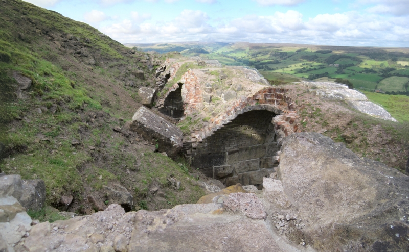
Calcining kilns. c1856, and later. For the Rosedale Mining Company.
Roughly squared stone faced with rusticated stone; interior lined with red
and cream bricks. Bank of 4 kilns, extended by a further 4 kilns. Openings
to the earlier kilns are narrow, round-headed arches of rusticated voussoirs
on rusticated piers. To right, 4 further kilns have wider, semicircular
arches similarly constructed of rusticated stone. To the rear of the
earlier bank of kilns the back wall survives, of rubble with flat coping
stones on top. The kilns have largely collapsed but sections of lining
bricks are visible behind the stone arches. No metal parts survive. The
kilns were constructed in association with the ironstone mine established in
1856 on the west side of Rosedale near Hollins Farm. They were built close
to the Bank Top terminus of the North Eastern Railway's Rosedale Branchline,
completed in 1861, from Ingleby on the Picton to Kildale line in Cleveland.
Ore was transported in rope-hauled wagons along a tramway from the mine to
the railway terminus where it was tipped into the kilns from above. It was
then roasted to drive off water and corbonic acid, thus reducing its weight
for onward transportation to County Durham and Teeside. With 2 temporary
closures in 1874 and 1879, the mine continued in operation until 1885. In
1864 the company's title was changed to the Rosedale and Ferryhill Iron
Company Ltd, and after the second closure a new company, The West Rosedale
Mine Company, was formed. R H Hayes and J G Rutter, Rosedale Mines and
Railway, Scarborough Archaeological and Historical Society, Research Report
No 9.
Listing NGR: SE7208994876
External links are from the relevant listing authority and, where applicable, Wikidata. Wikidata IDs may be related buildings as well as this specific building. If you want to add or update a link, you will need to do so by editing the Wikidata entry.


Other nearby listed buildings
