Approximate Location Map
Large Map »
Latitude: 51.4427 / 51°26'33"N
Longitude: -2.8406 / 2°50'26"W
OS Eastings: 341675
OS Northings: 171855
OS Grid: ST416718
Mapcode National: GBR JD.N86C
Mapcode Global: VH7C1.QZ5X
Plus Code: 9C3VC5V5+3Q
Entry Name: Church of All Saints
Listing Date: 5 April 1952
Grade: II
Source: Historic England
Source ID: 1129657
English Heritage Legacy ID: 33024
ID on this website: 101129657
Location: All Saints' Church, East Clevedon, North Somerset, BS21
County: North Somerset
Civil Parish: Clevedon
Traditional County: Somerset
Lieutenancy Area (Ceremonial County): Somerset
Tagged with: Church building
1. ALL SAINTS' LANE
5121
(North End)
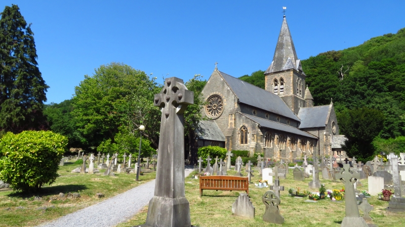
Church of All Saints,
East Clevedon
ST 4171 1/12 5.4.52.
C
2.
1861 by C E Giles. In Decorated style. Aisled nave. Central tower with spire.
Transepts with eastern chapels. Coursed rubble with ashlar dressings. Large
rose over west porch. Interior with octagonal nave columns and cinquefoil clerestory
windows.
Listing NGR: ST4167571855
External links are from the relevant listing authority and, where applicable, Wikidata. Wikidata IDs may be related buildings as well as this specific building. If you want to add or update a link, you will need to do so by editing the Wikidata entry.


Other nearby listed buildings
