Latitude: 53.3941 / 53°23'38"N
Longitude: -1.5559 / 1°33'21"W
OS Eastings: 429628
OS Northings: 388681
OS Grid: SK296886
Mapcode National: GBR KYK6.Y0
Mapcode Global: WHCCB.2YCC
Plus Code: 9C5W9CVV+MJ
Entry Name: Underbank Chapel
Listing Date: 25 April 1969
Grade: II
Source: Historic England
Source ID: 1132859
English Heritage Legacy ID: 335419
ID on this website: 101132859
Location: Nethergate, Sheffield, South Yorkshire, S6
County: Sheffield
Civil Parish: Bradfield
Traditional County: Yorkshire
Lieutenancy Area (Ceremonial County): South Yorkshire
Church of England Parish: Stannington Christ Church
Church of England Diocese: Sheffield
Tagged with: Church building
SK28NE BRADFIELD STANNINGTON ROAD (north side)
13/96 Underbank Chapel 25/4/69 GV II
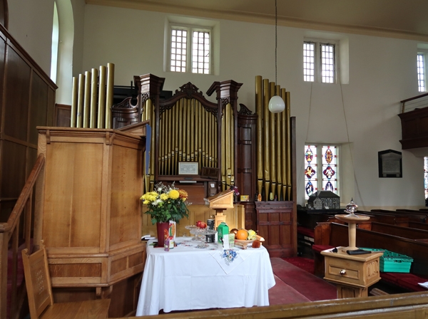
Unitarian Chapel. 1742-43, C19 and C20 interior. Coursed, squared sandstone, ashlar dressings, stone slate roof with central lead flat. 6 by 3 bays, symmetrical facades. 2 storeys. Plinth, projecting quoins, C18 panelled doors to bays 2 and 5 in matching ashlar surrounds with plinth blocks, monolithic jambs, deep stone lintels with projecting keystones and cornices. Bays 1 and 6 have a single light window to each floor all in square-faced surrounds with sill blocks, Central 2 bays each have a tall round-headed window in square-faced surrounds with sill blocks, impost blocks and tripartite keystones. Keyed oculus above each door. Moulded eaves cornice forms gutter. Hipped roof with ashlar stack to left of bay 1. Right return: 2-light square-faced mullion window to each bay on each floor, casements with glazing bars, Left return: 2 tall windows inserted, original central openings blocked. Interior: gallery to east end. In 1867 the pulpit was moved from the south wall to the west and original galleries to 3 sides removed. Further alterations in 1921 and 1952,
C. F. Stell, 'Underbank Chapel, Stannington', Archaeological Journal vol 137, 1980 pp455-6
Listing NGR: SK2961788672
External links are from the relevant listing authority and, where applicable, Wikidata. Wikidata IDs may be related buildings as well as this specific building. If you want to add or update a link, you will need to do so by editing the Wikidata entry.


Other nearby listed buildings