Approximate Location Map
Large Map »
Latitude: 51.6041 / 51°36'14"N
Longitude: -0.076 / 0°4'33"W
OS Eastings: 533343
OS Northings: 191223
OS Grid: TQ333912
Mapcode National: GBR H8.PHF
Mapcode Global: VHGQF.MYQ6
Plus Code: 9C3XJW3F+JJ
Entry Name: Tunnel Connecting East and West Portions of Tottenham Cemetery
Listing Date: 28 February 1995
Grade: II
Source: Historic England
Source ID: 1084331
English Heritage Legacy ID: 358695
ID on this website: 101084331
Location: Haringey, London, N17
County: London
District: Haringey
Electoral Ward/Division: White Hart Lane
Parish: Non Civil Parish
Built-Up Area: Haringey
Traditional County: Middlesex
Lieutenancy Area (Ceremonial County): Greater London
Church of England Parish: St John The Baptist Great Cambridge Road
Church of England Diocese: London
Tagged with: Building
TQ 33 91 HARINGEY
CHURCH LANE
(North West Side)
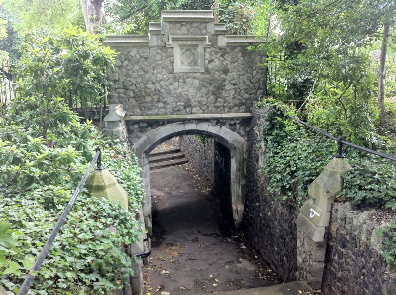
800-/7/10025 Tunnel connecting east and west
portions of Tottenham Cemetery
GV II
Tunnel connecting the eastern portion of Tottenham Cemetery with its western extension, opened
in 1883. Dated 1883 in plaques on gables to either side. Rock-faced stone with some ashlar
dressings. The structure comprises two retaining walls with gatepiers and wrought-iron railings on
top, lining a path that dips under the public footpath that cuts through the cemetery. The public
footpath is carried on an arch with stepped gables to either side, each with a plaque bearing a
trefoil and the date.
The tunnel forms a group with the chapel and links it to the war memorial.
Listing NGR: TQ3334391223
External links are from the relevant listing authority and, where applicable, Wikidata. Wikidata IDs may be related buildings as well as this specific building. If you want to add or update a link, you will need to do so by editing the Wikidata entry.


Other nearby listed buildings
