Approximate Location Map
Large Map »
Latitude: 51.4956 / 51°29'43"N
Longitude: -2.6595 / 2°39'34"W
OS Eastings: 354315
OS Northings: 177607
OS Grid: ST543776
Mapcode National: GBR JM.K5R2
Mapcode Global: VH88D.VNDW
Plus Code: 9C3VF8WR+66
Entry Name: Police Station and Attached Walls to North East and South West, Former Kings Weston Stables
Listing Date: 8 January 1959
Last Amended: 30 December 1994
Grade: II*
Source: Historic England
Source ID: 1187199
English Heritage Legacy ID: 380008
ID on this website: 101187199
Location: Lawrence Weston, Bristol, BS11
County: City of Bristol
Electoral Ward/Division: Avonmouth and Lawrence Weston
Parish: Non Civil Parish
Built-Up Area: Bristol
Traditional County: Gloucestershire
Lieutenancy Area (Ceremonial County): Bristol
Church of England Parish: Lawrence Weston St Peter
Church of England Diocese: Bristol
Tagged with: Police station
BRISTOL
ST5477 NAPIER MILES ROAD, Shirehampton
901-1/24/1752 (North West side)
08/01/59 Police Station and attached walls to
NE and SW, former Kings Weston
stables
(Formerly Listed as:
NAPIER MILES ROAD
(North side)
Kings Weston Police Station)
GV II*
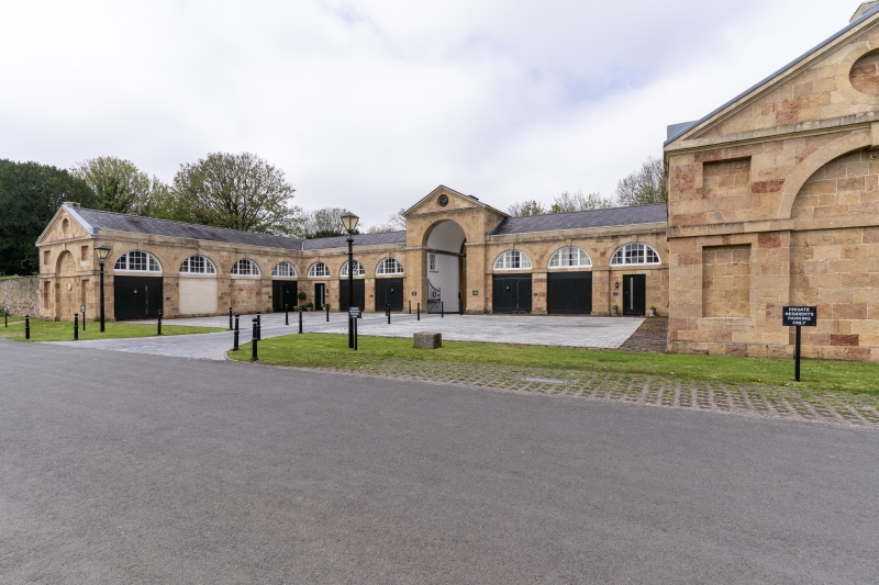
Stables, now police station. 1763. By Robert Mylne. Limestone
ashlar and slate roof. 3 sides to a quadrangle, single-depth
plan. 2 storeys; 14-window range. A symmetrical arrangement
with a tall central semicircular archway in a pedimented
gatehouse with a clock; either side are arcades of 3
semicircular arches linked by impost blocks with 6/6-pane
ground-floor sashes and lunettes in the arches, and 4-arch
arcades extending forward with vehicle doorways at the end;
cornice and parapet. Pedimented end gables have blind
semicircular arches and flat-headed niches around them and a
blind oculus in the pediment.
INTERIOR: rebuilt within the original walls for police
accommodation in 1959.
SUBSIDIARY FEATURES: attached rubble walls extend approx 50m
NE and SW of front wings, with central gateways with capped
piers, and terminating in piers formerly with ball finials.
Formerly the stables to Kings Weston House (qv). The attached
walls mirror those attached to the lodges of the former
kitchen garden (qv) opposite.
Listing NGR: ST5430777599
External links are from the relevant listing authority and, where applicable, Wikidata. Wikidata IDs may be related buildings as well as this specific building. If you want to add or update a link, you will need to do so by editing the Wikidata entry.


Other nearby listed buildings
