Approximate Location Map
Large Map »
Latitude: 51.4955 / 51°29'43"N
Longitude: -2.6588 / 2°39'31"W
OS Eastings: 354363
OS Northings: 177605
OS Grid: ST543776
Mapcode National: GBR JM.K5WG
Mapcode Global: VH88D.VNSW
Plus Code: 9C3VF8WR+6F
Entry Name: Two Lodges and Attached Garden Walls Opposite Former Kings Weston Stables
Listing Date: 8 January 1959
Last Amended: 30 December 1994
Grade: II*
Source: Historic England
Source ID: 1187186
English Heritage Legacy ID: 380012
ID on this website: 101187186
Location: Lawrence Weston, Bristol, BS11
County: City of Bristol
Electoral Ward/Division: Avonmouth and Lawrence Weston
Parish: Non Civil Parish
Built-Up Area: Bristol
Traditional County: Gloucestershire
Lieutenancy Area (Ceremonial County): Bristol
Church of England Parish: Lawrence Weston St Peter
Church of England Diocese: Bristol
Tagged with: Architectural structure
BRISTOL
ST5477 NAPIER MILES ROAD, Shirehampton
901-1/24/1755 (North West side)
08/01/59 Two lodges and attached garden walls
opposite former Kings Weston stables
(Formerly Listed as:
NAPIER MILES ROAD
(South side)
Two lodges and walling round pond
opposite Kings Weston Police Station)
GV II*
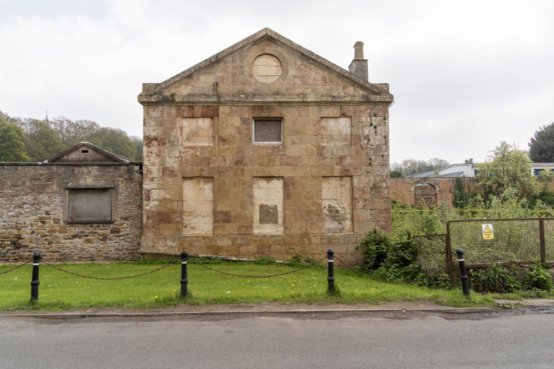
Lodges, pond and garden walls. 1763. By Robert Mylne.
Limestone ashlar and rubble, lateral stacks and slate roof,
with brick walls. Symmetrical plan of a central square pond
surrounded by garden wall, and flanked by square lodges.
Lodges are 2 storeys; 3-window range. Pedimented ashlar
lodges, blind to the road, with sash windows and door from the
garden; tall brick garden walls ramped up over ashlar
semicircular arches to the sides and middle of the back wall.
SUBSIDIARY FEATURES: attached flanking rubble walls to the
road extend approx 50m NE and SW from each lodge, with central
gateways, the right-hand one blocked, left-hand one has steel
spear-headed gates, with capped ashlar piers, and piers at
each end, that at the SW end with a ball finial. Brick walls
extend back from the road enclosing rectangular gardens. The
walls originally enclosed the kitchen garden of Kings Weston
House (qv).
Listing NGR: ST5436377605
External links are from the relevant listing authority and, where applicable, Wikidata. Wikidata IDs may be related buildings as well as this specific building. If you want to add or update a link, you will need to do so by editing the Wikidata entry.


Other nearby listed buildings
