Latitude: 53.4792 / 53°28'45"N
Longitude: -2.2311 / 2°13'52"W
OS Eastings: 384758
OS Northings: 398077
OS Grid: SJ847980
Mapcode National: GBR DMH.KS
Mapcode Global: WHB9G.PTR4
Plus Code: 9C5VFQH9+MH
Entry Name: London Warehouse
Listing Date: 3 October 1974
Grade: II
Source: Historic England
Source ID: 1217858
English Heritage Legacy ID: 388112
ID on this website: 101217858
Location: Ancoats, Manchester, Greater Manchester, M1
County: Manchester
Electoral Ward/Division: City Centre
Parish: Non Civil Parish
Built-Up Area: Manchester
Traditional County: Lancashire
Lieutenancy Area (Ceremonial County): Greater Manchester
Church of England Parish: Manchester St Ann
Church of England Diocese: Manchester
Tagged with: Warehouse
MANCHESTER
SJ8498SE DUCIE STREET 698-1/29/122 (South side) 03/10/74 London Warehouse
GV II
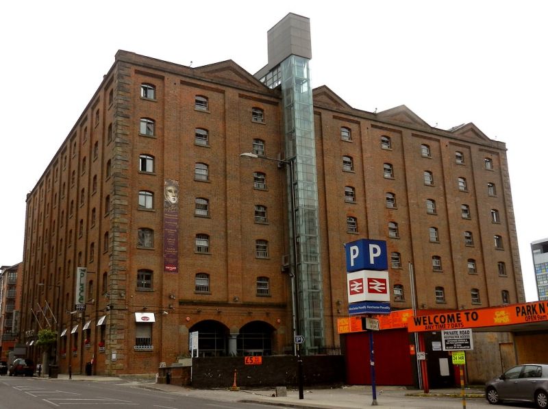
Railway warehouse. 1867, for Manchester, Sheffield and Lincolnshire Railway. Brown brick with stone dressings, roof concealed. Large square plan. Seven storeys and 9 bays, the bays slightly recessed between pilasters, with long-and-short quoins to the corners, stone cornice, and parapet with 4 gables; coupled segmental waggon arches in the 2nd and 3rd, and 6th and 7th bays; small segmental-headed windows with raised sills and small-pane glazing; fire-escape in front of windows of 8th bay. Ten-bay side walls, the south side with 3 pairs of former waggon arches (formerly covered by single-storey sheds and all now blocked); 3 pairs of similar arches in rear wall; fenestration in all these walls matching that of the front. Interior: massive cast-iron columns supporting large rivetted wrought-iron girders and cast-iron floor joists. Very prominent feature of Rochdale Canal basin site.
Listing NGR: SJ8475898077
External links are from the relevant listing authority and, where applicable, Wikidata. Wikidata IDs may be related buildings as well as this specific building. If you want to add or update a link, you will need to do so by editing the Wikidata entry.


Other nearby listed buildings