Approximate Location Map
Large Map »
Latitude: 51.4686 / 51°28'6"N
Longitude: -0.9808 / 0°58'50"W
OS Eastings: 470889
OS Northings: 174892
OS Grid: SU708748
Mapcode National: GBR QJ9.S0
Mapcode Global: VHDWS.YCB1
Plus Code: 9C3XF299+CM
Entry Name: Church of St Peter
Listing Date: 22 March 1957
Grade: II*
Source: Historic England
Source ID: 1303560
English Heritage Legacy ID: 38868
ID on this website: 101303560
Location: Caversham, Reading, Berkshire, RG4
County: Reading
Electoral Ward/Division: Thames
Parish: Non Civil Parish
Built-Up Area: Reading
Traditional County: Oxfordshire
Lieutenancy Area (Ceremonial County): Berkshire
Church of England Parish: Caversham Thameside and Mapledurham
Church of England Diocese: Oxford
Tagged with: Church building Norman architecture
This list entry was subject to a Minor Amendment on 20 February 2023 to reformat the text to current standards
SU 7074
11/265
Caversham
CHURCH ROAD (south side)
Church of St Peter
22.5.57.
II*
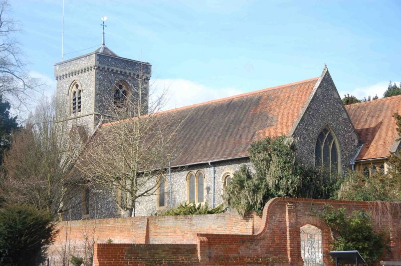
Church of England. Of various dates from C12, principally C15 and high Victorian. Pleasant flint built parish church with Bath stone dressings and old tile roof. West tower (1878) of three stages with hipped roof screened by high corbelled parapet, by Morris and Stallwood. Four gables to east (chancel and aisles of equal height, vestry to north slightly set back). Nothing remains of the Norman church except for the south doorway with crude chevron and a reset window now in the Vestry.
Five bay nave with three bay chancel (lengthened 1924-25 by Sir Ninian Comper). C15 north aisle with good perpendicular east chapel which has angel busts on capital; square frame three light windows. South aisle added 1878 (by Morris and Stallwood) three bays with three light east window with intersecting glazing.
Interior: nave has kingpost and wind brace roof. 1674 Loveday memorial in south aisle. Montague vault in north-east corner. Norman Purbeck marble font.
Listing NGR: SU7088974892
External links are from the relevant listing authority and, where applicable, Wikidata. Wikidata IDs may be related buildings as well as this specific building. If you want to add or update a link, you will need to do so by editing the Wikidata entry.


Other nearby listed buildings
