Approximate Location Map
Large Map »
Latitude: 51.4512 / 51°27'4"N
Longitude: -0.9643 / 0°57'51"W
OS Eastings: 472062
OS Northings: 172974
OS Grid: SU720729
Mapcode National: GBR QNH.G7
Mapcode Global: VHDWT.7SKD
Plus Code: 9C3XF22P+F7
Entry Name: Kendrick Girls' School No 41 (Kendrick Girls' School) Including Street Wall Extending to East and Turning into Sidmouth Street
Listing Date: 14 December 1978
Grade: II
Source: Historic England
Source ID: 1113505
English Heritage Legacy ID: 39001
ID on this website: 101113505
Location: Reading, Berkshire, RG1
County: Reading
Electoral Ward/Division: Katesgrove
Parish: Non Civil Parish
Built-Up Area: Reading
Traditional County: Berkshire
Lieutenancy Area (Ceremonial County): Berkshire
Church of England Parish: Reading St Giles
Church of England Diocese: Oxford
Tagged with: Building
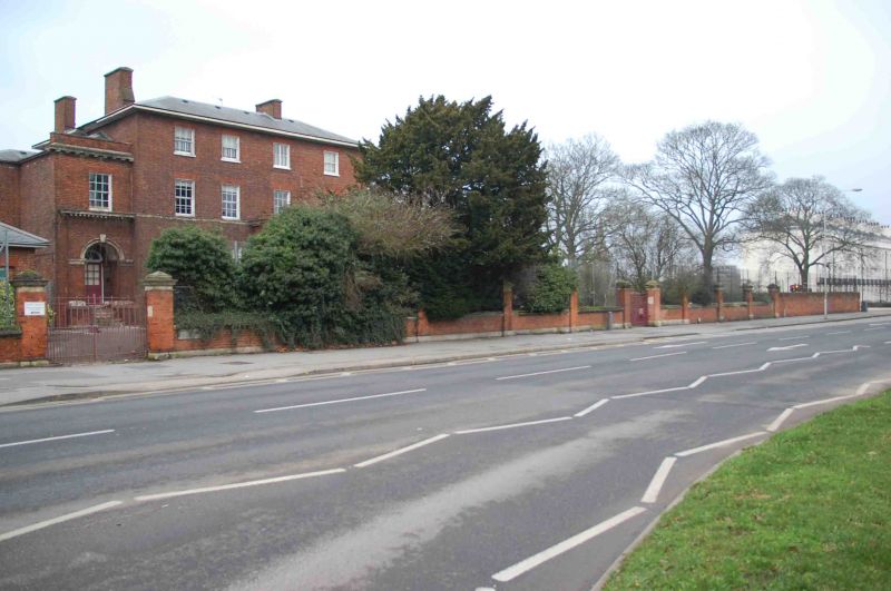
LONDON ROAD
1.
5128
(North Side)
No 41 (Kendrick Girls'
School)
Including street wall
extending to east and
turning into Sidmouth
Street
SU 7272 9/511
II GV
2.
Early-mid C19. Large imposing red brick detached house, altered. 3 storeys
and basement. Moulded string to ground floor level and at 1st floor cill level,
deep flat eaves, slate hipped roof. 4 ranges of glazing bar sash windows to
upper floors, 3 on ground floor with large central later projecting porch with
steps, arched entrance, coffered vault and double doors with fan (all of later
period). Later set back 2 storey 1 window extension to left with arched doorway
(stone surround) on ground floor and modillion cornice over. Full height shallow
bow with tripartite ground floor windows to right hand return. Small single
storey lodge to south-west with hipped roof. Later brick street wall with
moulded stone plinth and cope and tall moulded stone capped piers at intervals.
Rear altered: 2 storey projecting wing to north-west with rounded corner.
Street wall continued to Sidmouth Street about 5-6 ft red brick about 2 perches
long and turning corner.
Listing NGR: SU7206272974
External links are from the relevant listing authority and, where applicable, Wikidata. Wikidata IDs may be related buildings as well as this specific building. If you want to add or update a link, you will need to do so by editing the Wikidata entry.


Other nearby listed buildings
