Approximate Location Map
Large Map »
Latitude: 51.4586 / 51°27'30"N
Longitude: -1.004 / 1°0'14"W
OS Eastings: 469293
OS Northings: 173761
OS Grid: SU692737
Mapcode National: GBR QCD.LK
Mapcode Global: VHDWS.KL2P
Plus Code: 9C3WFX5W+C9
Entry Name: Keep and Attached Walls and Gateway, Brock Barracks
Listing Date: 22 December 1975
Last Amended: 8 July 1998
Grade: II
Source: Historic England
Source ID: 1156392
English Heritage Legacy ID: 39102
ID on this website: 101156392
Location: Reading, Berkshire, RG30
County: Reading
Electoral Ward/Division: Battle
Parish: Non Civil Parish
Built-Up Area: Reading
Traditional County: Berkshire
Lieutenancy Area (Ceremonial County): Berkshire
Church of England Parish: Tilehurst St George
Church of England Diocese: Oxford
Tagged with: Architectural structure
SU 67 SE READING OXFORD ROAD
(south side)
934/16/621
Keep and attached walls and
gateway, Brock barracks
(Formerly Listed as:
22.12.75 OXFORD ROAD
Brock Barracks: Keep and
attached gatehouse)
GV II
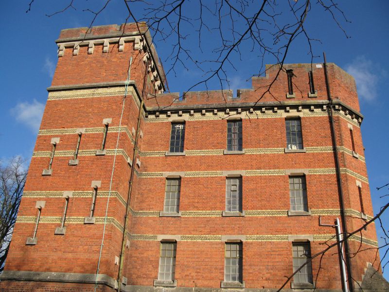
Armoury, guardhouse and store, disused. Dated 1877, designed at the War Office by Major HC Seddon, RE, supervising engineer Major Flint RE. Red brick with terracotta bands and stone dressings, lateral stacks and asphalt roof Fortress Tudor Gothic Revival style. PLAN: square, with ground-floor guard room and detention cells, corner stairs, stores on upper floors. EXTERIOR: 4 storeys; 5-window range. A regular, square block with opposite square stair towers rising above the roof, other 2 corners chamfered with raised parapets, with terracotta sill and lintel bands, dentil eaves and crenellated parapet. Battered ground floor to a weathered band, narrow metal-framed windows with stone lintels, stepped in threes to the stair tower. A glazed iron verandah to the guard house beside the entrance. INTERIOR: not inspected, but noted as having a fire-proof construction of iron columns to jack arches and stone open well stairs, and a standard plan with guard house, cells and various stores. SUBSIDIARY FEATURES: attached dwarf walls with iron railings extend 15m to the SE and SW of the front tower, and the former main entrance gate attached to the NW corner has a stepped parapet to a segmental arch, wickets either side. HISTORY: the keep was a secure armoury, store, guard house and lock up, and the characteristic building of the Localisation depots. They were part of the Cardwell reforms, which redistributed barracks around the country to encourage local connections and assist recruitment. As such, the keep raised the local profile of the barracks, and provided an emblematic focus for the regiment. Only ten examples survive, that at Brock also part, with Bodmin, of one of the two most complete surviving depots. (Watson Colonel Sir HM: History of the Corps of Royal Engineers: Chatham. 1954).
Listing NGR: SU6929373761
External links are from the relevant listing authority and, where applicable, Wikidata. Wikidata IDs may be related buildings as well as this specific building. If you want to add or update a link, you will need to do so by editing the Wikidata entry.


Other nearby listed buildings
