Latitude: 54.8988 / 54°53'55"N
Longitude: -1.4154 / 1°24'55"W
OS Eastings: 437590
OS Northings: 556168
OS Grid: NZ375561
Mapcode National: GBR V6P.Z5
Mapcode Global: WHD5C.7489
Plus Code: 9C6WVHXM+GV
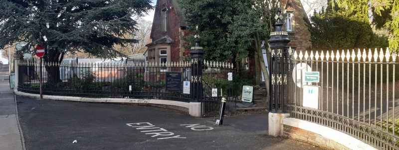
Entry Name: South Entrance Including Gates, Piers and Railings to Bishopwearmouth Cemetery
Listing Date: 17 October 1994
Grade: II
Source: Historic England
Source ID: 1207930
English Heritage Legacy ID: 391413
ID on this website: 101207930
Location: Bishopwearmouth Cemetery, High Barnes, Sunderland, Tyne and Wear, SR4
County: Sunderland
Electoral Ward/Division: Barnes
Parish: Non Civil Parish
Built-Up Area: Sunderland
Traditional County: Durham
Lieutenancy Area (Ceremonial County): Tyne and Wear
Church of England Parish: Bishopwearmouth St Gabriel
Church of England Diocese: Durham
Tagged with: Architectural structure
SUNDERLAND
NZ35NE CHESTER ROAD 920-1/4/30 (North side) South entrance incl. gates, piers & railings to Bishopwearmouth Cemetery
GV II
South entrance and boundary railings to Bishopwearmouth Cemetery. 1856. By Thomas Moore. Entrance piers and gates flanked by railings extending c200 metres to W and 200 metres to E along Chester Road. Painted cast-iron piers and railings; ashlar piers to flanking walls; brick dwarf walls with ashlar coping. Perpendicular style. Open octagonal cast-iron gate piers have central ornamental band; brattished decoration on high swept coping with bud finials. Gates have dog bars below pierced quatrefoil band, and lozenge-shaped bud finials. Serpentine walls with chamfered ashlar coping support railings, ramped to piers, with similar pierced band above shorter dogbars, and similar finials. Painted ashlar octagonal piers flank serpentine entrance walls and have brattished ornament on high coping. (Milburn GE and Miller ST: Sunderland River, Town and People: Sunderland: 1988-: 157; Corfe T: The Buildings of Sunderland 1814-1914: Newcastle: 1983-: 15).
Listing NGR: NZ3759056168
External links are from the relevant listing authority and, where applicable, Wikidata. Wikidata IDs may be related buildings as well as this specific building. If you want to add or update a link, you will need to do so by editing the Wikidata entry.


Other nearby listed buildings