Approximate Location Map
Large Map »
Latitude: 51.451 / 51°27'3"N
Longitude: -0.9704 / 0°58'13"W
OS Eastings: 471641
OS Northings: 172946
OS Grid: SU716729
Mapcode National: GBR QMH.39
Mapcode Global: VHDWT.4SBK
Plus Code: 9C3XF22H+9R
Entry Name: Church of St Giles and churchyard tombs
Listing Date: 22 March 1957
Grade: II
Source: Historic England
Source ID: 1113579
English Heritage Legacy ID: 39169
ID on this website: 101113579
Location: St Giles' Church, Reading, Berkshire, RG1
County: Reading
Electoral Ward/Division: Katesgrove
Parish: Non Civil Parish
Built-Up Area: Reading
Traditional County: Berkshire
Lieutenancy Area (Ceremonial County): Berkshire
Church of England Parish: Reading St Giles
Church of England Diocese: Oxford
Tagged with: Church building
SU 7172 NE
4/244-244A
SOUTHAMPTON STREET (east side)
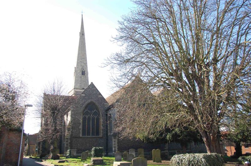
Church of St Giles and churchyard tombs
22.3.57.
GV
II
Church of England. The small medieval church was rebuilt 1872 by J.P. St Aubyn in Early English style retaining only the C13 aisle walls and Perpendicular west tower. Ashlar steeple 1873. Flint faced with Bath stone dressings. Tiled roof. Three bay aisled nave and slight transept. Y tracery lancet windows except
i. plate tracery twin 2-light lancets in belfry.
ii. 3 light Perpendicular west window.
iii. Good decorated-type trancept windows.
iv. Geometric east window.
Tower joins at skew and has corner and side buttresses. Pointed west door. Traces of mediaeval walling on south and west sides. Three bay chancel with flanking chapels.
Interior: rich Early English-style chancel. Norman fragments in tower (a capital possibly from the Abbey). Early C16 brass to John and Jane Bowyer. A number of good C18 memorial tablets and a good sculpted memorial to Harwood Awberry (date 1748) by Peter Scheemakers.
The graveyard retains much of its C19 atmosphere and contains a number of good tombs.
To south-west: three chest tombs, the nearest to the church corner is best: early C19 to Thomas Patrick Sourdon, tapering sides, cross gabled capping with corner antefixae. The two others are circa 1840 with fluted corners.
To north-west and east: another good group of both table and pyramidal-capped tombs. The best is to William Granger circa 1840 - similar to the Sourdon tomb (see above) with incised corner piers. Also notable (1) William Green and Woodard family vault - a late C18 chest tomb. Circa 1811, Portland stone, moulded plinth, oval panels to front and back. A number of tombs at the east end face true east (ie aligned slightly differently from the chancel).
Listing NGR: SU7164172946
External links are from the relevant listing authority and, where applicable, Wikidata. Wikidata IDs may be related buildings as well as this specific building. If you want to add or update a link, you will need to do so by editing the Wikidata entry.


Other nearby listed buildings
