Latitude: 51.3631 / 51°21'47"N
Longitude: -1.9913 / 1°59'28"W
OS Eastings: 400699
OS Northings: 162674
OS Grid: SU006626
Mapcode National: GBR 2TV.FCH
Mapcode Global: VHB48.FZMX
Plus Code: 9C3W9275+7F
Entry Name: Roundway House
Listing Date: 19 March 1962
Grade: II
Source: Historic England
Source ID: 1243319
English Heritage Legacy ID: 447044
ID on this website: 101243319
Location: Roundway, Wiltshire, SN10
County: Wiltshire
Civil Parish: Roundway
Traditional County: Wiltshire
Lieutenancy Area (Ceremonial County): Wiltshire
Tagged with: House
ROUNDWAY ROUNDWAY PARK SU 06 SW 5/219 Roundway House 19.3.62 II
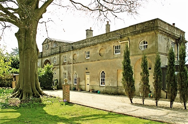
Two sides of stable court of demolished Roundway Park, late C18, probably by James Wyatt. Ashlar with slate roofs, 2 storeys, L- plan. Plinth, string course, moulded cornice and parapet. Left range has been altered in conversion to house, 2:5:2 window range with centre projecting slightly. Sides have 6-pane upper windows over 12-pane lower windows. Centre has first floor oval light and 6-pane window each side, no centre opening. Oval lights are C20. Ground floor has 2 large blank arches framing C20 twelve-pane sashes with oval plaques over and centre C20 open pedimented doorcase, which replaces a similar blank arch framing an arched doorway. C20 eight-pane sash to ground floor each side. Long entrance range of 5:3:5 bays, the wings with 6-pane upper windows and ground floor 12-pane windows, 6-panel doors with overlights in end bays of each wing. Centrepiece in triumphal arch form, high central carriage arch, slightly projected side bays with arched- headed double doors, string course and 6-pane upper windows. Side bays have blind balustrading, centre has raised attic with pediment over round clock. Panelled piers each side. Rear of this range is similar but openings mostly blind and alternating arched panels with rectangular panels on ground floor, circular panels with square panels above. End bays of wings project slightly. Roundway Park was built 1777-83 for J. Sutton by James Wyatt, altered 1841-2 by T. Finden for E.F. Colston and held by the Colston family, Lords Roundway until c1948. The house was demolished in 1955.
Listing NGR: SU0069962674
External links are from the relevant listing authority and, where applicable, Wikidata. Wikidata IDs may be related buildings as well as this specific building. If you want to add or update a link, you will need to do so by editing the Wikidata entry.


Other nearby listed buildings