Latitude: 54.211 / 54°12'39"N
Longitude: -2.8885 / 2°53'18"W
OS Eastings: 342152
OS Northings: 479839
OS Grid: SD421798
Mapcode National: GBR 8M8R.G7
Mapcode Global: WH83D.LFR3
Plus Code: 9C6V6466+CJ
Entry Name: Castle Head
Listing Date: 2 May 1975
Last Amended: 12 July 1996
Grade: II
Source: Historic England
Source ID: 1269676
English Heritage Legacy ID: 460525
ID on this website: 101269676
Location: Lindale, Westmorland and Furness, Cumbria, LA11
County: Westmorland and Furness
District: South Lakeland
Civil Parish: Grange-over-Sands
Traditional County: Lancashire
Lieutenancy Area (Ceremonial County): Cumbria
Church of England Parish: Lindale St Paul
Church of England Diocese: Carlisle
Tagged with: English country house
GRANGE-OVER-SANDS
SD47NW LINDALE ROAD 705-1/2/17 (East side (off)) 02/05/75 Castle Head (Formerly Listed as: LINDALE ROAD Castle Head (excluding modern blocks to north and south))
II
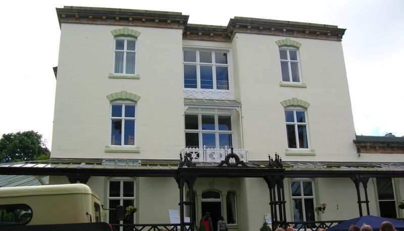
Large house, now field centre. Late C18. For J Wilkinson. Extensively re-modelled and extended in the later C19, with further C20 additions made when used as a school. Painted render with slate roofs. PLAN AND EXTERIOR: the earliest part of the building is of rectangular plan with 2 parallel hipped roofs, of 3 storeys, with the 3 main facades of 3 window bays each and having a continuous timber verandah (part glazed and part slated). The windows are timber casements and those to the outer window bays of each facade have projecting sills, plain reveals, and segmental arches with keystones and chamfered voussoirs. The central window bays to the north and south are recessed, with wider timber casements on the 1st and 2nd floors, and doorways on the ground floor. The east facade has a 3-storey canted bay window. The verandah is supported on paired timber posts and has latticework balustrading. Near the main entrance there is cresting with the initial 'M': the house was owned by Edward Mucklow in the late C19. The facades have bracketed cornice gutters. HISTORY: the house was built for John Wilkinson (1728-1808) the iron master and is raised above the adjoining mosslands which he drained and improved from 1778 onwards. Despite its late C19 appearance, an early C19 view reproduced by JM Robinson shows that the walls, the roof shape, and the positions of the openings, remain from the original house. The further C20 blocks to the north and south are not of special architectural interest. (Robinson JM: A Guide to the Country Houses of the North-West: London: 1991-: 171).
Listing NGR: SD4215279839
External links are from the relevant listing authority and, where applicable, Wikidata. Wikidata IDs may be related buildings as well as this specific building. If you want to add or update a link, you will need to do so by editing the Wikidata entry.


Other nearby listed buildings