Latitude: 53.7801 / 53°46'48"N
Longitude: -2.2353 / 2°14'7"W
OS Eastings: 384591
OS Northings: 431551
OS Grid: SD845315
Mapcode National: GBR DSTQ.VP
Mapcode Global: WHB83.M7SZ
Plus Code: 9C5VQQJ7+2V
Entry Name: Hufling Hall
Listing Date: 29 September 1977
Grade: II
Source: Historic England
Source ID: 1244849
English Heritage Legacy ID: 467085
ID on this website: 101244849
Location: Burnley Wood, Burnley, Lancashire, BB11
County: Lancashire
District: Burnley
Electoral Ward/Division: Rosehill with Burnley Wood
Parish: Non Civil Parish
Built-Up Area: Burnley
Traditional County: Lancashire
Lieutenancy Area (Ceremonial County): Lancashire
Church of England Parish: Burnley St Stephen
Church of England Diocese: Blackburn
Tagged with: House
BURNLEY
SD83SW HUFLING LANE, Burnley Wood 906-1/3/169 (North side) 29/09/77 Nos.69 AND 71 Hufling Hall
II
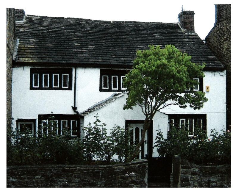
Farmhouse, now 2 dwellings. Late C17 or very early C18; altered. Coursed sandstone rubble with quoins, the front rendered and painted white, stone slate roof and hand-made brick chimneys. Double-depth double-fronted plan, slightly set back from road between Nos 67 & 73 (not included) which adjoin to right and left respectively. 2 low storeys and 3 windows, almost symmetrical. The ground floor has an added gabled porch offset left of centre, with a doorway which has a plain surround, and an inserted doorway at the left end; both floors have double-chamfered stone mullioned windows, that to the right at ground floor of 3+3 lights with a king mullion and all the others of 4 lights. Gable chimneys (that to the left truncated). Rear: altered openings including 2 plain doorways and rectangular windows with C20 glazing. INTERIOR not inspected. HISTORY: an unusual combination of C17 features and a full double-depth plan characteristic of the C18; and, in its setting among later C19 terraced houses, a striking illustration of historical change.
Listing NGR: SD8459131551
External links are from the relevant listing authority and, where applicable, Wikidata. Wikidata IDs may be related buildings as well as this specific building. If you want to add or update a link, you will need to do so by editing the Wikidata entry.


Other nearby listed buildings