Latitude: 50.6073 / 50°36'26"N
Longitude: -2.4554 / 2°27'19"W
OS Eastings: 367867
OS Northings: 78716
OS Grid: SY678787
Mapcode National: GBR PY.DNYW
Mapcode Global: FRA 57RG.F7B
Plus Code: 9C2VJG4V+WR
Entry Name: Town Bridge
Listing Date: 22 December 1997
Grade: II
Source: Historic England
Source ID: 1313402
English Heritage Legacy ID: 467252
Also known as: Weymouth Town Bridge
ID on this website: 101313402
Location: Weymouth, Dorset, DT4
County: Dorset
Electoral Ward/Division: Melcombe Regis
Parish: Weymouth
Built-Up Area: Weymouth
Traditional County: Dorset
Lieutenancy Area (Ceremonial County): Dorset
Church of England Parish: Radipole and Melcombe Regis
Church of England Diocese: Salisbury
Tagged with: Road bridge Bascule bridge
WEYMOUTH
SY6778NE Town Bridge 873-1/23/2
GV II
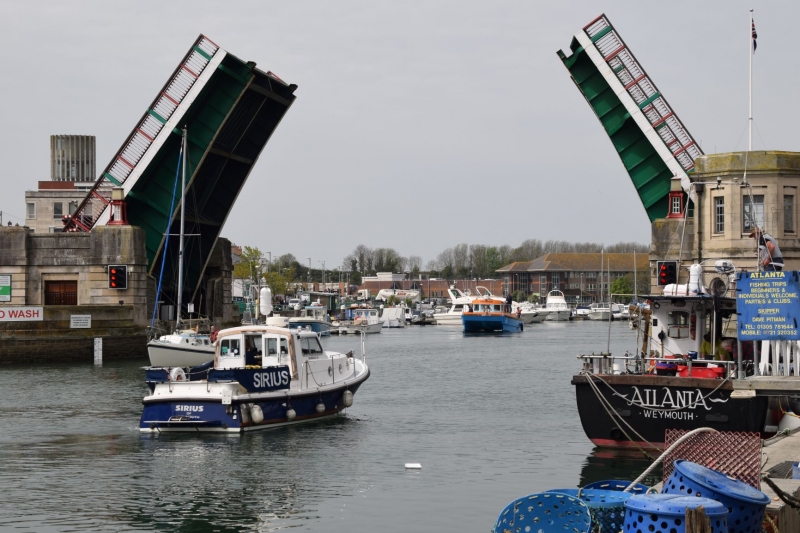
Bascule road bridge crossing the Harbour, and linking Old Weymouth with Melcombe Regis. 1930. Steel bascules, Portland ashlar abutments and arches with some coursed sandstone. The bridge has a nearly level roadway carried on bascules to a flat segmental arch between formal abutments with square corner buttresses. At the S end, connecting with Trinity Road, a parapet wall to the height of the abutments swings round in a segment, and the Harbour wall is swept round to meet it, containing a small platform to the W, and a similar platform to the E, but with a set of steps within ashlar walls. At the N end, leading into St Thomas Street, there is a similar abutment, with a pavilion for the bridge controller, then 2 low segmental arches over the quayside road, with stone parapets, stopped on the E side to a flight of 20 steps to the Quay level. The bascule section has a steel balustrade in 10 panels each side, with a broad teak handrail. The end abutments are in channelled ashlar, with a square opening with paired doors at the lower level, surmounted by a cornice at roadway level. The corner buttresses provide recessed embayments at pavement level, and an entry to the control building on the NE unit; they are terminated with prominent steel lanterns, 6 in all, on open truncated pyramidal bases and with a trellis top. The control pavilion has a low stone weathered roof above a cornice, and is semi-octagonal on the E side, with a glazed door from the pavement, and a single casement to 5 outer facets, above 4 oculi and a door on the water side. At the St Thomas Street end the 2 segmental arches over the low road are in concrete cast on permanent steel shuttering, and there is a low connecting arch in the wall between the 2 throughways; most of the stonework here, and in the lower parts of the abutment retaining walls, is in grey sandstone. There are 4 commemorative plaques or tablets: on the NW abutment, in the embayment facing the pavement, is a granite panel inscribed: 'From Weymouth New England to Weymouth in Old England: 1930', and on the opposite side a bronze plate records 'This bridge was opened by HRH the Duke of York on the 4th July 1930.....', also gives Bolton and Larkin Ltd as the general contractors, Cleveland Bridge and Engineering Co Ltd as steelwork contractors, and RW Vince as the Borough
Surveyor. At the S end, to the E the plaque records the Council members for 1929/30, and opposite the bronze plaque gives historical information about this and previous bridges. It also records that the bridge was built by the Corporation, the cost being shared between the Borough Council, Dorset County Council and the Ministry of Transport. Town Bridge inevitably holds an important position visually in the town, and has been designed to give a dignified character. At the same time it is of considerable historical interest; a bridge was built, to replace a rope ferry, in 1597, rebuilt 3 times in the C18, the last in 1769, when it was moved from the former alignment opposite Nicholas Street to the present location. In 1821 a new 'permanent' bridge was sought, and built in 1824. This is known to have had a toll gate at the Melcombe Regis end in 1857. The 1824 bridge was replaced by the present structure which has importance in the townscape. It is a fine example of its type displaying both technological and architectural virtuosity. (Ricketts E: The Buildings of Old Weymouth: Melcombe Regis and Westham: Weymouth: 1975-: 111).
Listing NGR: SY6786778716
External links are from the relevant listing authority and, where applicable, Wikidata. Wikidata IDs may be related buildings as well as this specific building. If you want to add or update a link, you will need to do so by editing the Wikidata entry.


Other nearby listed buildings