Approximate Location Map
Large Map »
Latitude: 51.4987 / 51°29'55"N
Longitude: -0.1048 / 0°6'17"W
OS Eastings: 531651
OS Northings: 179453
OS Grid: TQ316794
Mapcode National: GBR NJ.MY
Mapcode Global: VHGR0.4LGG
Plus Code: 9C3XFVXW+F3
Entry Name: Obelisk at the Centre of St George's Circus
Listing Date: 2 March 1950
Last Amended: 14 June 2000
Grade: II*
Source: Historic England
Source ID: 1385642
English Heritage Legacy ID: 471046
ID on this website: 101385642
Location: North Southwark, Southwark, London, SE1
County: London
District: Southwark
Electoral Ward/Division: Cathedrals
Parish: Non Civil Parish
Built-Up Area: Southwark
Traditional County: Surrey
Lieutenancy Area (Ceremonial County): Greater London
Church of England Parish: Waterloo St John with St Andrew
Church of England Diocese: Southwark
SOUTHWARK
TQ3179 ST GEORGE'S CIRCUS
636-1/4/464
02/03/1950 Obelisk at the centre of
St George's Circus
II*
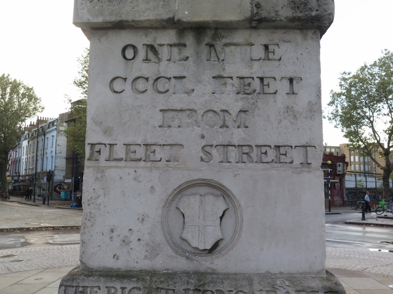
Obelisk. 1771. Robert Mylne. Stone. Removed from St George's
Circus in 1905.Inscribed as follows: north face: ERECTED IN XI YEAR OF
THE REIGN OF KING GEORGE THE THIRD. MDCCLXXI. THE RIGHT HONOURABLE
BRASS CROSBY ESQUIRE, LORD MAYOR. South face: ONE MILE, CCCL
FEET FROM FLEET STREET. Arms of the City of London below. East
face: ONE MILE FROM PALACE YARD, WESTMINSTER HALL. West face:
ONE MILE, XXXX FEET FROM LONDON BRIDGE.
HISTORY. this obelisk was erected in 1771 in the centre of St George's Circus as part of the grand planning scheme designed by Mylne for Blackfriars Bridge Road. It provided the focal point(and signpost) for the radiating roads leading to various parts of the city from the entrance from the south. In c1897 it was removed to make way for a Victoria Diamond Jubilee clock-tower and was re-erected in the Geraldine Mary Harmsworth Park on Lambeth Road where it was included in the List in 1950. In 1998 it was re-erected in its original position. The obelisk forms a significant group with the Duke of Clarence Public House no 32 London Road (qv), Nos 123-131 London Road (qv, Nos 113-119 Borough Road (qv and the former Presbyterian Chapel (qv) and St George the Martyr Library (qv), also Borough Road.
Listing NGR: TQ3165179453
External links are from the relevant listing authority and, where applicable, Wikidata. Wikidata IDs may be related buildings as well as this specific building. If you want to add or update a link, you will need to do so by editing the Wikidata entry.


Other nearby listed buildings
