Latitude: 51.8665 / 51°51'59"N
Longitude: -2.2486 / 2°14'54"W
OS Eastings: 382979
OS Northings: 218682
OS Grid: SO829186
Mapcode National: GBR 1KZ.VQW
Mapcode Global: VH94B.ZC40
Plus Code: 9C3VVQ82+HH
Entry Name: Shire Hall
Listing Date: 23 January 1952
Grade: II
Source: Historic England
Source ID: 1245084
English Heritage Legacy ID: 472683
ID on this website: 101245084
Location: Gloucester, Gloucestershire, GL1
County: Gloucestershire
District: Gloucester
Electoral Ward/Division: Westgate
Parish: Non Civil Parish
Built-Up Area: Gloucester
Traditional County: Gloucestershire
Lieutenancy Area (Ceremonial County): Gloucestershire
Church of England Parish: Hempsted with Gloucester, Saint Mary de Lode and Saint Mary de Crypt
Church of England Diocese: Gloucester
Tagged with: Administrative building
GLOUCESTER
SO8218NE WESTGATE STREET 844-1/7/429 (South side) 23/01/52 Shire Hall
GV II
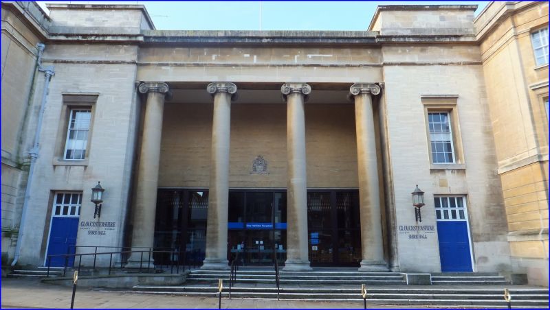
Shire hall portico and flanking wings. The original building, of which the portico remains, opened 1816. By Sir Robert Smirke for the County Magistrates. Substantial extensions to either side of entrance front, 1909-11, by MH Medland for Gloucestershire County Council. The entrance portico and the flanking wings retained when building was otherwise demolished and rebuilt with major additions, 1960-1970. Ashlar, composite roof. The original symmetrical facade, comprising portico between slightly projecting wings, is set back from street between later, flanking wings; the wider flanking wing on the east side returns along the west side of Berkeley Street. EXTERIOR: giant Ionic portico of three bays flanked by two-storey, single-bay wings is approached by two shallow flights of stone steps in forecourt flanked by later wings, above the portico the crowning entablature is slightly recessed between parapets with moulded copings above the single bay wings; on the front of each wing a central doorway and on the first floor a sash. The later projecting wings, of three storeys and basement, have canted angles at the outer corners on the sides towards the forecourt, plain ashlar plinths at basement level, raised bands at ground-floor sill level with banded rustication above capped by raised bands at first-floor sill level; the first and second floors faced with plain ashlar, crowning entablatures with parapets with open balustrade panels; all the sashes with glazing bars; a bronze sconce on each side of the portico. INTERIOR: mostly rebuilt 1960 to 1970. The Assize Courts at rear, formerly listed as part of Shire Hall, now listed as Crown Courts, Bearland (qv). (BOE: Verey D: Gloucestershire: The Vale and the Forest of Dean: London: 1976-: 239; VCH: The City of Gloucester: Oxford: 1988-: 249).
Listing NGR: SO8297918682
External links are from the relevant listing authority and, where applicable, Wikidata. Wikidata IDs may be related buildings as well as this specific building. If you want to add or update a link, you will need to do so by editing the Wikidata entry.


Other nearby listed buildings