Approximate Location Map
Large Map »
Latitude: 52.2015 / 52°12'5"N
Longitude: 0.1162 / 0°6'58"E
OS Eastings: 544716
OS Northings: 258025
OS Grid: TL447580
Mapcode National: GBR L79.S8Q
Mapcode Global: VHHK2.YXSQ
Plus Code: 9F426428+HF
Entry Name: The Mill Public House
Listing Date: 2 November 1972
Grade: II
Source: Historic England
Source ID: 1126140
English Heritage Legacy ID: 47618
ID on this website: 101126140
Location: Cambridge, Cambridgeshire, CB2
County: Cambridgeshire
District: Cambridge
Electoral Ward/Division: Market
Parish: Non Civil Parish
Built-Up Area: Cambridge
Traditional County: Cambridgeshire
Lieutenancy Area (Ceremonial County): Cambridgeshire
Church of England Parish: Cambridge St Mary the Less
Church of England Diocese: Ely
Tagged with: Pub
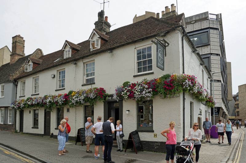
MILL LANE
1.
942
Nos 13 & 14
(The Mill
Public House)
TL 4458 SE 6/49
II GV
2.
Late C18. Brick, upper storey to Mill Lane plastered. 5 windows facing
Mill Lane, square headed, some with glazing bars. 3 pedimented dormers
to Mill Lane, 1 to Granta Place. Tiled roof.
Nos 12 to 14 form a group.
Listing NGR: TL4471658025
External links are from the relevant listing authority and, where applicable, Wikidata. Wikidata IDs may be related buildings as well as this specific building. If you want to add or update a link, you will need to do so by editing the Wikidata entry.


Other nearby listed buildings
