Approximate Location Map
Large Map »
Latitude: 50.7997 / 50°47'58"N
Longitude: -1.106 / 1°6'21"W
OS Eastings: 463098
OS Northings: 100392
OS Grid: SU630003
Mapcode National: GBR VNN.BL
Mapcode Global: FRA 86KZ.JXQ
Plus Code: 9C2WQVXV+VH
Entry Name: Dockyard Wall Victory Gate and Dockyard Wall
Listing Date: 13 August 1999
Grade: II*
Source: Historic England
Source ID: 1244581
English Heritage Legacy ID: 476664
ID on this website: 101244581
Location: Portsea, Portsmouth, Hampshire, PO1
County: City of Portsmouth
Electoral Ward/Division: Charles Dickens
Parish: Non Civil Parish
Built-Up Area: Portsmouth
Traditional County: Hampshire
Lieutenancy Area (Ceremonial County): Hampshire
Church of England Parish: St Thomas of Canterbury, Portsmouth
Church of England Diocese: Portsmouth
Tagged with: Wall
SU 6300 SW MAIN ROAD
HM Naval Base
Victory Gate and Dockyard Wall
774-1/30/229
GV II*
Includes: Dockyard Wall, ADMIRAL TV ROAD HM NAVAL BASE
Includes: Dockyard Wall, BONFIRE CORNER HM NAVAL BASE
Includes: Dockyard Wall, MARLBOROUGH ROW HM NAVAL BASE
Includes: Dockyard Wall, QUEEN STREET HM NAVAL BASE
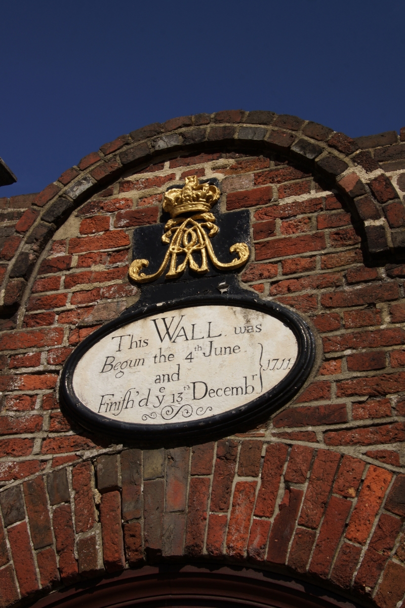
Dockyard entrance and wall. Dated 1704-12; gate widened 1949; C20 repairs to wall. Wall of red brick with some blue headers in English bond. It is slightly battered and at regular intervals has pilaster buttresses with oversailing offset heads rising into the oversailing, ridged triangular- sectioned brick coping. The wall steps and ramps, varying in height from approximately 4 metres to approximately 7 metres and at the taller sections having narrower pilasters rising from the buttresses into the coping. At various points it is incorporated in the buildings which have been built up against it: at the former RN Academy (building nos 1/14-19, qv) on Queen Street, the wall matches the Academy, being of grey brick in header bond; and, having returned along Admiralty Road, there is a former entrance to the Academy, now blocked, having a stone sill, plinth blocks, and impost blocks carrying a round arch of bright red bricks. At Bonfire Corner, the top of the date "1711" picked out in blue headers is visible above pavement level. There are also 2 stones carved with a fouled anchor. Turning north, the wall has several C20 interruptions before ending at building no. 1/138 (qv), the former gatehouse to Marlborough Gate (which originally was at this point). Along this stretch, at building no. 2/121 (qv), formerly stables, a lower spur wall later heightened, encloses the former stable yard, and at yard entrance has square brick piers with ashlar capstans and cannon barrels reused as bollards.Running from this yard wall, another low section continues along the north side of the garden of Spithead House (qv Long Row), having gateway and later (probably 19305) addition with flat ashlar coping. The main dockyard entrance, Victory Gate, has 2 large ashlar piers with moulded plinths, arrises and cornices, and golden ball-on-cushion finials. At base of each pier is a late C19 cast-iron bollard in the form of an imitation inverted cannon barrel with cannon ball in muzzle. Panelled double gate with iron spikes. In wall on each side is a similar pedestrian gate in segmental-arched opening. Above right-hand gate the coping of the wall is interrupted by a semicircular pediment framing royal cipher and crown and surmounting an oval datestone in architrave inscribed, "This wall was begun the 4th June and finished ye 13th December 1711".
HISTORY: the wall follows generally the line of Sir Bernard de Gomme's earth-rampart town defences which were constructed from 1665 on, and which the wall replaced as a yard perimeter. The earliest entrance to a naval yard, and the gate is part of a group with the contemporary Porter's Lodge (qv). (Sources: Coad J: Historic Architecture of HM Naval Base Portsmouth 1700- 1850: Portsmouth: 1989: 4, plate 1; The Buildings of England: Lloyd D: Hampshire and the Isle of Wight: Harmondsworth: 1985: 408-9,419).
SU 6300 SW ADMIRALTY ROAD
HM Naval Base Dockyard Wall
774-1/30/229
GV II*
See under: Victory Gate and Dockyard Wall, MAIN ROAD HM NAVAL BASE
SU 6300 SW BONFIRE CORNER
HM Naval Base Dockyard Wall
774-1/30/229
GV II*
See under: Victory Gate and Dockyard Wall, MAIN ROAD HM NAVAL BASE
SU 6300 SW MARLBOROUGH ROW
HM Naval Base Dockyard Wall
774-1/30/229
GV II*
See under: Victory Gate and Dockyard Wall, MAIN ROAD HM NAVAL BASE
SU 6300 SW QUEEN STREET
HM Naval Base Dockyard Wall
774-1/30/229
GV II*
See under: Victory Gate and Dockyard Wall, MAIN ROAD HM NAVAL BASE
Listing NGR: SU6299200361
External links are from the relevant listing authority and, where applicable, Wikidata. Wikidata IDs may be related buildings as well as this specific building. If you want to add or update a link, you will need to do so by editing the Wikidata entry.


Other nearby listed buildings
