Approximate Location Map
Large Map »
Latitude: 51.4461 / 51°26'45"N
Longitude: -2.6219 / 2°37'18"W
OS Eastings: 356879
OS Northings: 172083
OS Grid: ST568720
Mapcode National: GBR C2N.2G
Mapcode Global: VH88M.HXS9
Plus Code: 9C3VC9WH+C7
Entry Name: Ashton Swing Bridge
Listing Date: 24 May 2000
Grade: II
Source: Historic England
Source ID: 1380341
English Heritage Legacy ID: 480343
ID on this website: 101380341
Location: Hotwells, Bristol, BS1
County: City of Bristol
Electoral Ward/Division: Hotwells and Harbourside
Parish: Non Civil Parish
Built-Up Area: Bristol
Traditional County: Somerset
Lieutenancy Area (Ceremonial County): Bristol
Church of England Parish: Clifton Holy Trinity with St Andrew the Less and St Peter
Church of England Diocese: Bristol
Tagged with: Bridge Road bridge Swing bridge Railway bridge
ST5672 BRISTOL
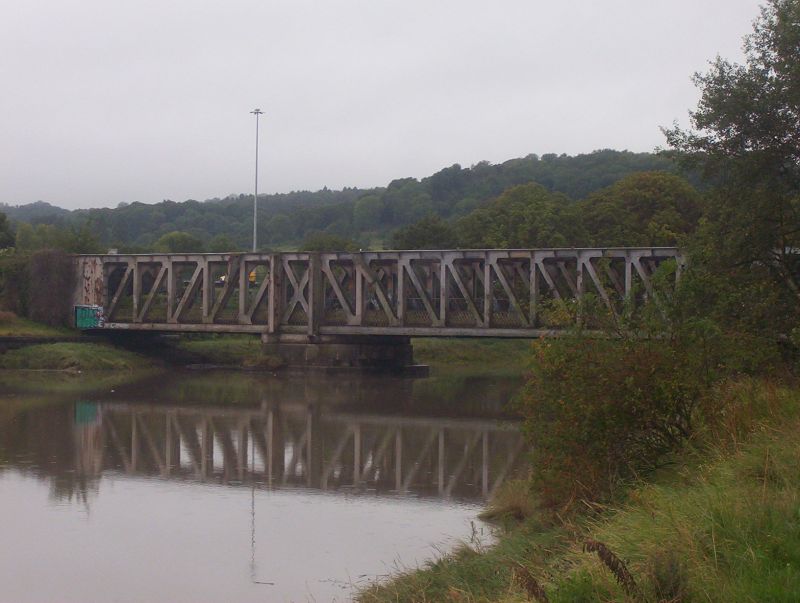
901-1/41/10087 Ashton Swing Bridge
II
Railway and road hydraulic swing bridge, nowfixed. 1905-6 for Bristol Corporation and the Great Western Railway, chief engineer j.C.lnglis, contractor john Lysaght and Co of Bristol, hydraulic machinery by Armstrong Whitworth and Co. Steel, with squared rock faced limestone abutments. Two piers with the southern one supporting the swinging apparatus. Enormous Whipple Murphy truss swinging span weighing some 1000 tons which carried a double track line to the north bank of the Avon New Cut thus opening up the south side of the Floating Harbour to rail traffic as well as the north bank via the Cumberland Basin bridge.
History: This bridge was constructed as a part of the Bristol Harbour lines from the Portishead branch to Canon's Marsh and Wapping' Wharf which opened on 4-10-1906. It was a joint initiative by the City and the GWR but the great cost of ?70,000 fell mainly on the Corporation as the railway had agreed to pay only ?18,000, which was the first estimate. It originally carried a road, and the operating cabin at the top of the girder but there is now little sign of this; it still carries a single rail track. It was operated hydraulically from the dock system and used 182 gallons of water a time. It was one of the last installations added to the docks hydraulic system. In early years it was swung on average 10 times a day, but this soon declined and it has not been swung since 1936. Bristol Corporation rescinded the obligation on the railway to maintain it as an opening bridge in 1951. The road deck and operating cabin were removed following the completion of the new road system associated with the Plimsoll Bridge in 1965. It is an unusual example of a combined road/rail swing bridge.
References: E.T.MacDermot, History of the Great Western Railway, Ian Allan, revised ed. 1964,
Vol II, p 228.
John Lord and Jem Southam, The Floating Harbour, The Redcliffe Press, 1983, pps 47-8,64-5,77-8.
Listing NGR: ST5687972083
External links are from the relevant listing authority and, where applicable, Wikidata. Wikidata IDs may be related buildings as well as this specific building. If you want to add or update a link, you will need to do so by editing the Wikidata entry.


Other nearby listed buildings
