Approximate Location Map
Large Map »
Latitude: 53.5552 / 53°33'18"N
Longitude: -2.3513 / 2°21'4"W
OS Eastings: 376824
OS Northings: 406568
OS Grid: SD768065
Mapcode National: GBR DW0B.R8
Mapcode Global: WH97W.VWJW
Plus Code: 9C5VHJ4X+3F
Entry Name: Water Powered Beam Pump
Listing Date: 10 June 2010
Grade: II
Source: Historic England
Source ID: 1393833
English Heritage Legacy ID: 506624
ID on this website: 101393833
Location: Bury, Greater Manchester, M26
County: Bury
Electoral Ward/Division: Radcliffe West
Parish: Non Civil Parish
Traditional County: Lancashire
Lieutenancy Area (Ceremonial County): Greater Manchester
Church of England Parish: Radcliffe St Thomas and St John
Church of England Diocese: Manchester
Tagged with: Architectural structure
BURY
326/0/10081 MOUNT SION ROAD
10-JUN-10 RADCLIFFE
(Off)
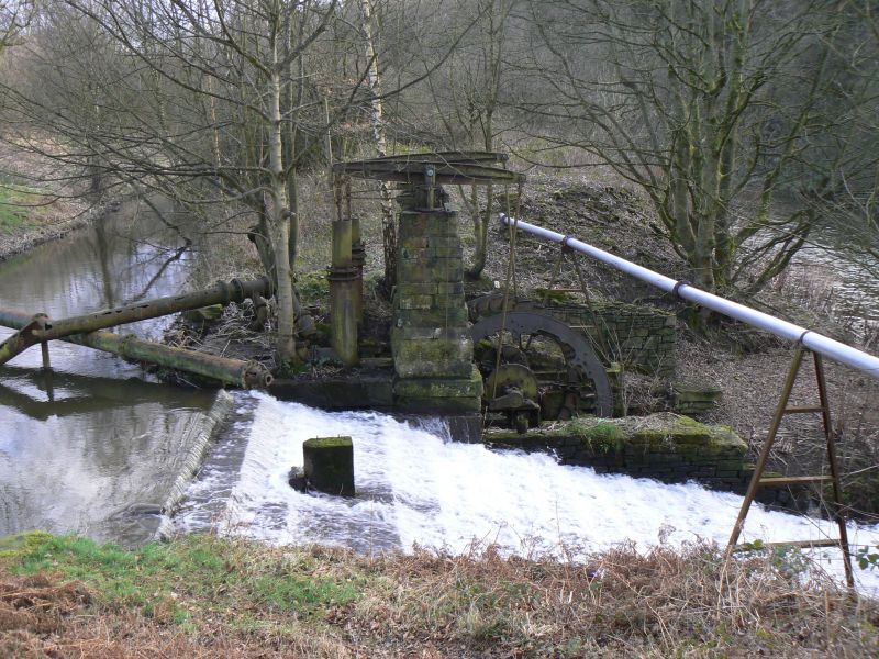
WATER POWERED BEAM PUMP
II
A former water-powered beam pump of early C19 date originally associated with the Mount Sion Mill, Radcliffe.
MATERIALS: A wrought and cast iron pump with stone pillars, spillway, wheelpit and retaining wall.
PLAN: The structure is rectangular in plan.
EXTERIOR: Two tapering sandstone stone pillars approximately 2m tall rise one from each side of a stone-lined wheelpit and support the cast iron rocker mechanism for the pumping rods which were attached and driven by the waterwheel. The wheel has eccentric cams on the outer hub plates which powered the pump rods. The wheel, its axle and driving gear remain within the wheelpit although timber water buckets and other timberwork has eroded. The wheel was a low breast wheel with water falling into the buckets at mid-point on its circumference. Stop-plank beam slots are visible on the goit-side of the wheelpit walls to hold back the water when the pump was not used. The pumps, pistons and pipe work all remain in situ.
Immediately to the west of the pump is a stepped stone spillway taking overflow water from the goit down into the river while immediately to the east of the pump there is a part-filled stone-lined spillway with retaining wall that provided the same function.
HISTORY: Mount Sion Mill is thought to have been built in the first half of the C19 and is depicted on the Ordnance Survey map of 1850 as `Mount Sion Print Works'. Reservoirs lie to the east of the mill as does a weir and goit. Water in the goit was used to turn a waterwheel which powered the beam engine to pump water into the reservoirs at a time of water shortage. Spillways or overflows were constructed immediately adjacent to the pump to take excess water from the goit down into the river. On post-1850 maps the mill is depicted as a bleach works. During World War I the works was used to manufacture guncotton. In 1918 the bleach works burnt down. At an unspecified date the site became Mount Sion Papermill and it remains in use as a pulp processing plant.
SOURCES:
Ordnance Survey Map 1st edition 1:10,560, 1850.
Sunderland, Frank, The Book of Radcliffe p.73. 1995.
REASONS FOR DECISION: The early-mid C19 Mount Sion beam pump, Radcliffe, is designated at Grade II for the following principal reasons:
* Rarity: the Mount Sion beam pump survives in a relatively good condition, still retains most of its component parts and is an unusual survival of its type
* Intactness: the pump's level of survival means that it is still clearly possible to understand how it functioned
* Interest: the surviving adjacent goit and reservoirs illustrate clearly how the water management system at the former mill was powered and supplied by the beam pump.
Yes list.
External links are from the relevant listing authority and, where applicable, Wikidata. Wikidata IDs may be related buildings as well as this specific building. If you want to add or update a link, you will need to do so by editing the Wikidata entry.


Other nearby listed buildings
