Approximate Location Map
Large Map »
Latitude: 53.2895 / 53°17'22"N
Longitude: -2.1514 / 2°9'4"W
OS Eastings: 390005
OS Northings: 376954
OS Grid: SJ900769
Mapcode National: GBR FZFD.1J
Mapcode Global: WHBBG.XLQ2
Plus Code: 9C5V7RQX+QC
Entry Name: National Westminster Bank
Listing Date: 25 July 1952
Grade: II*
Source: Historic England
Source ID: 1329653
English Heritage Legacy ID: 58372
ID on this website: 101329653
Location: Prestbury, Cheshire East, Cheshire, SK10
County: Cheshire East
Civil Parish: Prestbury
Built-Up Area: Macclesfield
Traditional County: Cheshire
Lieutenancy Area (Ceremonial County): Cheshire
Church of England Parish: Prestbury St Peter
Church of England Diocese: Chester
Tagged with: Bank building
SJ 97 NW PRESTBURY C.P. THE VILLAGE
(West Side)
5/206 & 6/206 National Westminster
Bank (formerly listed
as Priest's House)
25/7/1952
GV II*
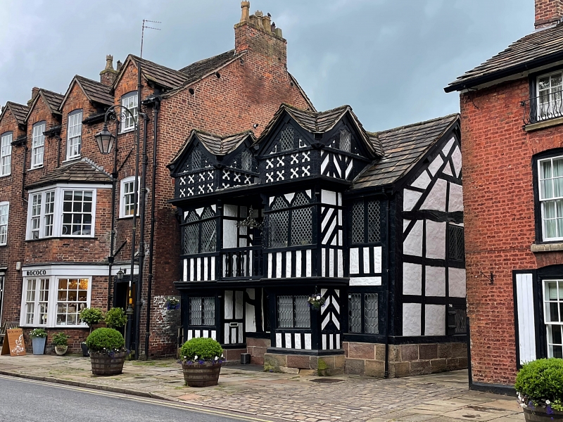
Formerly vicarage (known as Priest's House) later cottages and now a
bank. C16 origins. Much earlier C17 work complete and sympathetic
restoration 1968-70. Timber framed on ashlar sandstone plinth.
Kerridge stone-slate roof and stone ridge. 2½ storey, near
symmetrical 5-bay front. 2nd and 4th bays are square projections
rising 2½ storeys with cross gabled roofs to dormers. Lower storey
has 2-light casements with applied lozenge shaped glazing. Above are
2-light windows with trefoil shaped heads, some with original lattice
leaded glazing. Fronts and sides of dormers have cross motifs in
small panels and single lights. Between these bays at 1st floor is a
balcony with flat shaped balusters and wainscotting behind. Other
bays use similar elements. Tiny circular light on the centre of the
ridge. Right gable has a tiebeam and collar truss and considerable
buff sandstone extensions to the rear.
Interior: Much altered to bank's needs but 2 cast iron firebacks
found in the restoration displayed in the banking hall. One is dated
1635 and with the arms of Charles I, and the other is late C17/C18,
Dutch in origin.
This building, replaced as vicarage by the Manor House (q.v.) in 1708,
has a distinctive and lopsided appearance and forms the focal point of
the village street.
Listing NGR: SJ9000576954
External links are from the relevant listing authority and, where applicable, Wikidata. Wikidata IDs may be related buildings as well as this specific building. If you want to add or update a link, you will need to do so by editing the Wikidata entry.


Other nearby listed buildings
