Approximate Location Map
Large Map »
Latitude: 50.7914 / 50°47'29"N
Longitude: -4.5151 / 4°30'54"W
OS Eastings: 222831
OS Northings: 102107
OS Grid: SS228021
Mapcode National: GBR K3.ZJ1J
Mapcode Global: FRA 17F0.2TN
Plus Code: 9C2QQFRM+HX
Entry Name: Viaduct About 180 Metres North East of Woolston Farmhouse
Listing Date: 9 September 1985
Grade: II*
Source: Historic England
Source ID: 1328572
English Heritage Legacy ID: 64935
ID on this website: 101328572
Location: Cornwall, EX23
County: Cornwall
Civil Parish: Poundstock
Traditional County: Cornwall
Lieutenancy Area (Ceremonial County): Cornwall
Church of England Parish: Poundstock
Church of England Diocese: Truro
Tagged with: Railway viaduct
SS 20 SW POUNDSTOCK
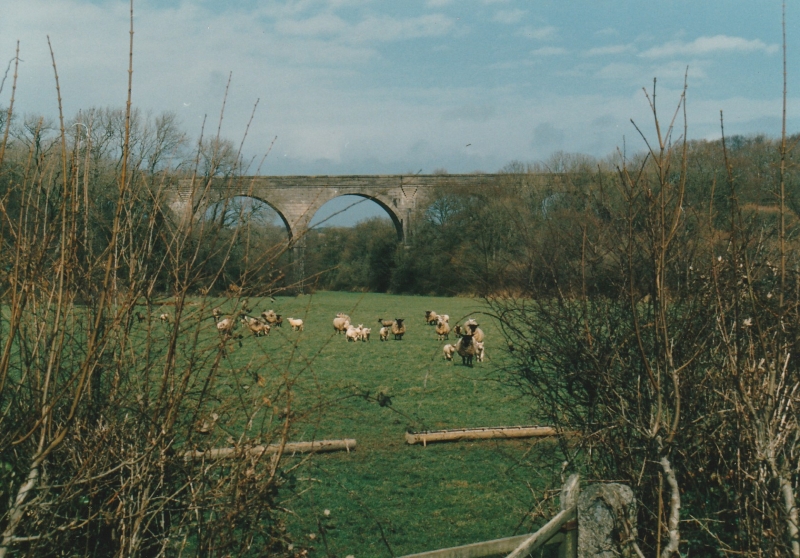
7/133 Viaduct about 180 metres north
- east of Woolston Farmhouse
- II*
Railway viaduct, formerly carrying the Holsworthy to Bude railway. 1898.
Chamfered rusticated concrete block laid in Flemish bond. 5-span viaduct with
parapets. Round arches spring from chamfered imposts on piers of rectangular
section. Parapet has moulded cornice, string course below parapet has plain
coping. Datestone in parapet carved on plaque on corbelled out refuge. The line
from Holsworthy to Bude was built by the LSWR and opened 1898 and closed in 1966.
Concrete blocks were used in housing in the 1860s, but this structure may be the
earliest example of their use in bridge construction. Similar viaduct on the same
line at Holsworthy.
C.C.Stanley, Cement and Concrete Association.
Listing NGR: SS2283102107
External links are from the relevant listing authority and, where applicable, Wikidata. Wikidata IDs may be related buildings as well as this specific building. If you want to add or update a link, you will need to do so by editing the Wikidata entry.


Other nearby listed buildings
