Approximate Location Map
Large Map »
Latitude: 50.6386 / 50°38'18"N
Longitude: -4.6753 / 4°40'30"W
OS Eastings: 210927
OS Northings: 85517
OS Grid: SX109855
Mapcode National: GBR N4.94X1
Mapcode Global: FRA 173D.0FJ
Plus Code: 9C2QJ8QF+CV
Entry Name: Slaughterbridge 500 Metres to South East of Worthy Manor
Listing Date: 13 January 1988
Grade: II
Source: Historic England
Source ID: 1142724
English Heritage Legacy ID: 68478
ID on this website: 101142724
Location: Slaughterbridge, Cornwall, PL32
County: Cornwall
Civil Parish: Camelford
Traditional County: Cornwall
Lieutenancy Area (Ceremonial County): Cornwall
Church of England Parish: Lanteglos by Camelford
Church of England Diocese: Truro
Tagged with: Road bridge
SX 18 NW
2/34
FORRABURY AND MINSTER
CAMELFORD, PART IN
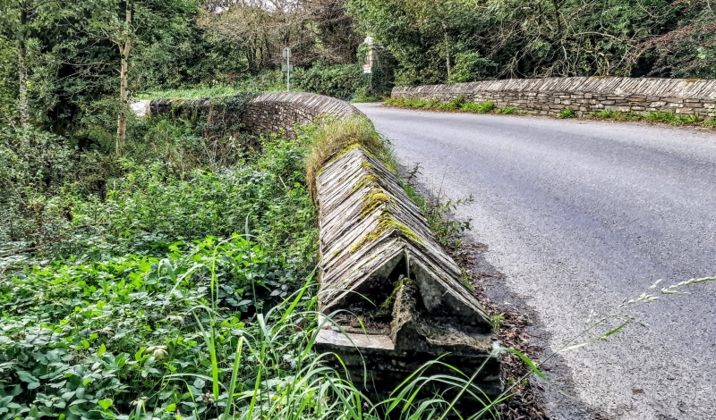
Slaughter bridge 500 metres to south east of Worthyvale Manor
GV
II
Roadbridge over River Camel. Probably C18. Slate stone rubble and granite. Central span with 2 narrower spans flanking, all 3 with roughly cut granite lintels. 2 stone rubble cutwaters. The slate stone rubble parapets have been partly renewed and are splayed over the abutments.
Traditionally associated with the site of King Arthur's last battle. King Arthur's stone which probably commemorates Catinus, son of Magarus is sited nearby at SX109856 and is scheduled as an Ancient Monument.
The name may derive from the word 'slohtre' meaning a marsh or muddy place.
Henderson, C. and Coates, H. Old Cornish Bridges and Streams, 1928 reprinted 1972.
Canner, A. C. The Parish of Tintagel, some historical notes, 1982.
The asset was previously listed twice also at List entry 1143488. This entry was removed from the List on 3rd August 2015.
External links are from the relevant listing authority and, where applicable, Wikidata. Wikidata IDs may be related buildings as well as this specific building. If you want to add or update a link, you will need to do so by editing the Wikidata entry.


Other nearby listed buildings
