Approximate Location Map
Large Map »
Latitude: 50.6591 / 50°39'32"N
Longitude: -3.3028 / 3°18'10"W
OS Eastings: 308008
OS Northings: 85187
OS Grid: SY080851
Mapcode National: GBR P7.77MS
Mapcode Global: FRA 37ZB.F3P
Plus Code: 9C2RMM5W+JV
Entry Name: St Michaels Close
Listing Date: 30 June 1961
Last Amended: 10 February 1987
Grade: II
Source: Historic England
Source ID: 1204742
English Heritage Legacy ID: 86346
ID on this website: 101204742
Location: Otterton, East Devon, EX9
County: Devon
District: East Devon
Civil Parish: Otterton
Built-Up Area: Otterton
Traditional County: Devon
Lieutenancy Area (Ceremonial County): Devon
Church of England Parish: Otterton St Michael
Church of England Diocese: Exeter
Tagged with: Building
OTTERTON CHURCH HILL, Otterton
SY 0885
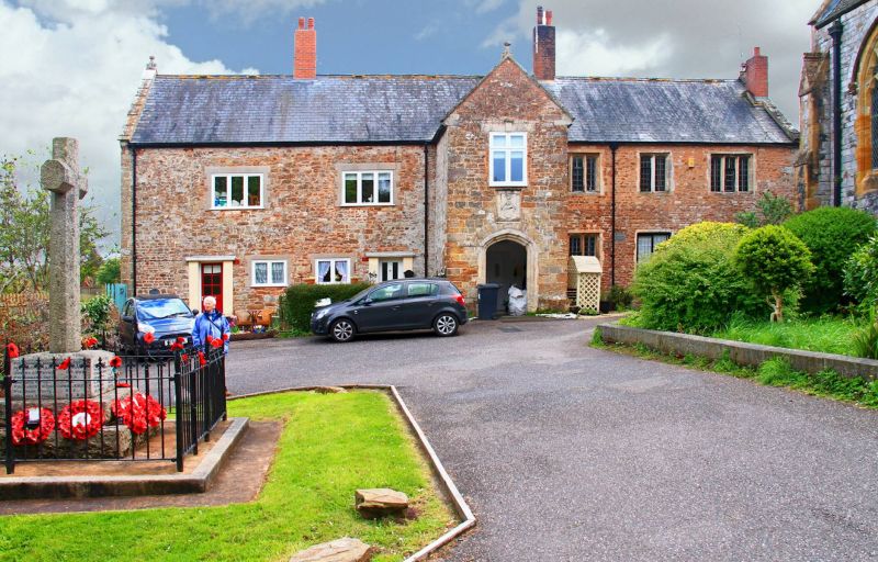
7/145 Nos. 1, 2, 3 and 4 St Michaels
Close (formerly listed as The
30.6.61 Priory)
GV II
Almhouses, former manor house built on monastic site. Early or mid C16, some C18
improvements, radically altered and rearranged in late C19 and again circa 1970.
Roughly-squared stone blocks, mostly local conglomerate sandstone but including some
of other sandstones and some volcanic trap; Beerstone ashlar detail; stone rubble
and brick stacks topped with late C19 brick; slate roof.
4 adjoining cottage almshouses facing west. Nos.1 and 2 are at the left (northern)
end and each is 1 room wide a 2 deep and there is an axial stack between the two.
Nos. 3 and 4 are 2-room plan cottages served by an axial and 2 gable end stacks at
the right (southern) end. No. 3 occupies the front rooms and its doorway is through
a 2-storey porch slightly right of centre of the whole block. No. 4 occupies rear
rooms and is entered through the back.
2:1:3-window front. Nos. 1 and 2 to left of the porch have 1 window each, all circa
1970 casements without glazing bars and with concrete lintels. Either end of this
section are contemporary part-glazed doors. The masonry here is random rubble and
has been much disturbed in the C19 and C20. The gabled porch outer arch is a
richly-moulded Beerstone four-centred arch. Inside is a moulded cornice. There
is a C20 front door into No.3. Directly above the outer arch is a Beerstone plaque.
Here set between pilasters and below a moulded entablature is an heraldic
achievement in bas relief; the arms of William Duke (mayor of Exeter in 1460)
quartered with those of Cecily Poer. Above this is a C20 mullion-and-transom window
under a probably C18 Beerstone flat arch with keystone. There are blocked windows
each side of the porch and in the angle between porch and main block right is what
appears to be part of a disused first floor chimney stack. Most of the 3-window
section right of the porch contains C16 2- and 3-light limestone windows with 3-
centred heads to the lights and sunken spandrels. The ground floor centre and right
windows are timber casements with flat-faced mullions, possibly as early as the C18.
All these contain timber casements and rectangular panes of leaded glass. The roof
is gable-ended. All the gables, including that of the porch, have shaped kneelers,
coping and stone finials. The north end, overlooking Otterton village, contains a
blocked window on each floor; a massive 4-light mullion-and-transom window to the
ground floor and a 2-light first floor window. All the lights have 3-centred heads
with sunken spandrels and both windows have hoodmoulds. The windows look C16 but
are built of a different limestone to those on the main front. The rear elevation
is plastered and contains only circa 1970 fenestration. The right (southern) end is
blind. Here, however, the lower section of the rear chimney shaft is limestone
ashlar.
Interior: Nothing shows earlier than the late C19 and most detail dates from circa
1970. Roof not accessible but is believed to date from late C19 or C20. Some early
features may survive behind later plaster and there is a tradition in the village of
a blocked cellar under the south end with stone doorways.
Although the arms seem to date from the late C15 it is thought that this building
was erected after the dissolution of the monastery here in the C16. The surviving
detail would support a C16 rather than C15 date.
Listing NGR: SY0800885187
External links are from the relevant listing authority and, where applicable, Wikidata. Wikidata IDs may be related buildings as well as this specific building. If you want to add or update a link, you will need to do so by editing the Wikidata entry.


Other nearby listed buildings
