Approximate Location Map
Large Map »
Latitude: 55.8831 / 55°52'59"N
Longitude: -3.1145 / 3°6'52"W
OS Eastings: 330381
OS Northings: 666109
OS Grid: NT303661
Mapcode National: GBR 60PD.JX
Mapcode Global: WH6T1.4D69
Plus Code: 9C7RVVMP+66
Entry Name: Bridge, High Street, Lasswade
Listing Name: Lasswade, High Street, Lasswade Bridge, River North Esk
Listing Date: 16 September 1979
Category: B
Source: Historic Scotland
Source ID: 357966
Historic Scotland Designation Reference: LB22406
Building Class: Cultural
ID on this website: 200357966
Location: Bonnyrigg and Lasswade
County: Midlothian
Town: Bonnyrigg And Lasswade
Electoral Ward: Bonnyrigg
Traditional County: Midlothian
Tagged with: Bridge
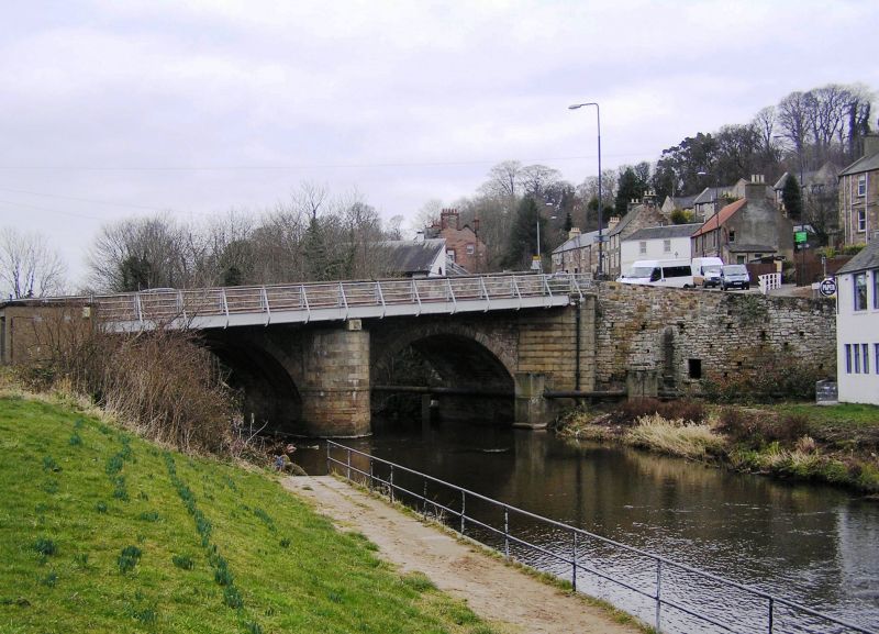
18th century with later repairs. Sandstone rubble parapet to SW with ridged ashlar cope; cast-iron and concrete pedestrian path flanking SW parapet; ashlar sandstone parapet to NE with square ashlar cope.
2 ashlar sandstone segmental arches with ashlar voussoirs, soffits and abutments. Full-height triangular-plan cutwater between arches to SW; half-height triangular-plan cutwater to NE with tapered buttress above.
Carrying the road over the River North Esk, linking Lasswade and Bonnyrigg with the thoroughfare to Edinburgh. In close proximity to
the tollhouse on the north bank, a charge (toll) would have been levied at his point for using the bridge and accompanying section of road. The minute book charts the catalogue of problems involved with the upkeep of Lasswade Bridge; on 8th April, 1776, it was noted that the bridge needed repairs and a James Henderson, mason, gave an estimate of the costs involved (not noted). By 30th April, there was talk of replacing the bridge with a new one although this does not seem to have come to anything as, by 25th May, an Alexander Steven, mason, quoted ?70 for the repair and upkeep of the bridge for a period of
7 years. At this meeting it was noted that both Henderson and Steven submitted plans for a new bridge although, from later entries, it seems that the Trustees opted for an ongoing repair regime. By 1795 there were plans afoot to widen the bridge and to repair the abutments, which had recently fallen down. Much repaired and altered since, including the addition if a pedestrian walkway to SW. Upgraded to category B, 22-Nov-91. Tollhouse listed separately.
External links are from the relevant listing authority and, where applicable, Wikidata. Wikidata IDs may be related buildings as well as this specific building. If you want to add or update a link, you will need to do so by editing the Wikidata entry.


Other nearby listed buildings
