Approximate Location Map
Large Map »
Latitude: 51.5622 / 51°33'44"N
Longitude: -3.7298 / 3°43'47"W
OS Eastings: 280193
OS Northings: 186235
OS Grid: SS801862
Mapcode National: GBR H6.DSMH
Mapcode Global: VH5H2.9ZLS
Plus Code: 9C3RH76C+V3
Entry Name: Ruined Undercroft at St Mary's Abbey
Listing Date: 12 November 1952
Last Amended: 25 April 2000
Grade: I
Source: Cadw
Source ID: 14150
Building Class: Religious, Ritual and Funerary
ID on this website: 300014150
Location: Located to the S of the Chapter House and E of Margam Orangery.
County: Neath Port Talbot
Town: Port Talbot
Community: Margam
Community: Margam
Locality: Margam Park
Traditional County: Glamorgan
Tagged with: Building
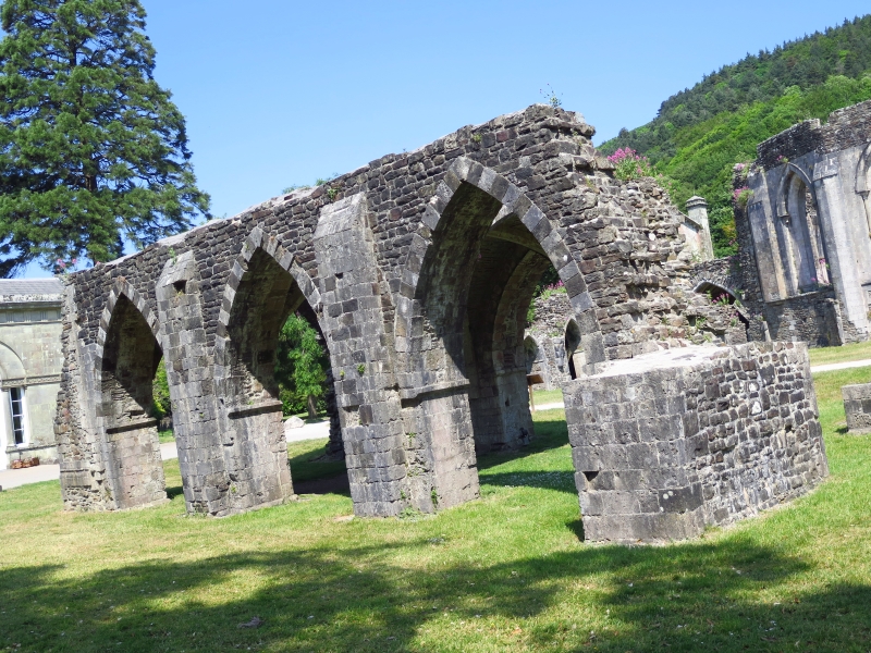
Robert of Gloucester, Earl of Glamorgan, granted lands for a Cistercian Abbey at Margam in 1147. Most of the nave of the original C12 abbey church survives and is now the parish church. The rest of the abbey church and the remaining monastic buildings were rebuilt in Early English style in the early C13, probably in 1203-13 under Abbot Gilbert. The undercroft belongs to this phase. It supported a storey above, probably a bridge leading to the monks' dormitory at right angles to the W. Alternatively, the upper storey could have been part of the dormitory or even an infirmary, although the latter is likely to have been in a more isolated position.
Margam Abbey was dissolved by the crown visitors of Henry VIII in 1536-7 and the monks evicted. By 1540, Sir Rice Mansel (1487-1859) of Oxwich and Old Beaupre had acquired most of the former monastic lands. He built an impressive Tudor house, incorporating some of the monastic remains into the service areas.
Three-bay vaulted structure orientated E-W of roughly coursed stone with quoins. Arcade of 3 pointed arches surviving to just above apex level, but the E arch of the N side is no longer extant. Low impost band to arches, chamfered to underside. Pilasters to fronts of piers. Wide arches to E and W ends, the dressings no longer surviving. The E piers are built into short N-S walls with quoins, possibly demarcating a corridor or range beyond. A break in this wall further N suggests a doorway. Large pier or wall fragment against N side of NW pier, while a short wall joins the W side of the SW pier. Quadripartite ribbed vaults survive to the W and central bays. Low scalloped corbels between the vaults support chamfered ribs.
Listed grade I as a rare survival in S Wales of a medieval monastic building. Group value with Abbey Church of St Mary and chapter house.
Scheduled Ancient Monument GM005 (NEP).
External links are from the relevant listing authority and, where applicable, Wikidata. Wikidata IDs may be related buildings as well as this specific building. If you want to add or update a link, you will need to do so by editing the Wikidata entry.


Other nearby listed buildings
